You are here: Home > Network List > TA - USArray Transportable Network (new EarthScope stations) Stations List
> Station A22K Sinclair Lake, AK, USA > Earthquake Result Viewer
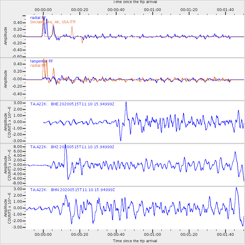
A22K Sinclair Lake, AK, USA - Earthquake Result Viewer
| Earthquake location: |
Nevada |
| Earthquake latitude/longitude: |
38.2/-117.9 |
| Earthquake time(UTC): |
2020/05/15 (136) 11:03:26 GMT |
| Earthquake Depth: |
0.4 km |
| Earthquake Magnitude: |
6.5 Mww |
| Earthquake Catalog/Contributor: |
NEIC PDE/nn |
|
| Network: |
TA USArray Transportable Network (new EarthScope stations) |
| Station: |
A22K Sinclair Lake, AK, USA |
| Lat/Lon: |
71.00 N/154.97 W |
| Elevation: |
6.0 m |
|
| Distance: |
38.1 deg |
| Az: |
341.318 deg |
| Baz: |
129.553 deg |
| Ray Param: |
0.07580162 |
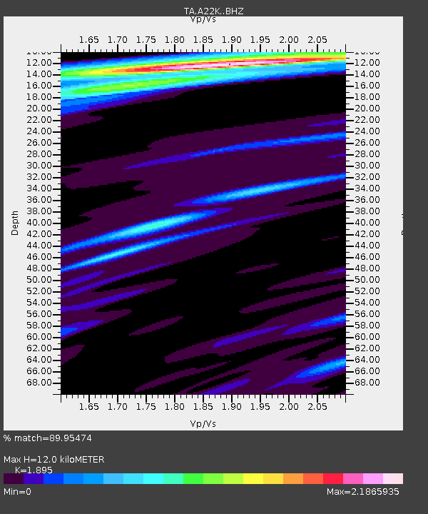
| Estimated Moho Depth: |
12.0 km |
| Estimated Crust Vp/Vs: |
1.89 |
| Assumed Crust Vp: |
5.782 km/s |
| Estimated Crust Vs: |
3.051 km/s |
| Estimated Crust Poisson's Ratio: |
0.31 |
|
| Radial Match: |
89.95474 % |
| Radial Bump: |
286 |
| Transverse Match: |
70.82178 % |
| Transverse Bump: |
400 |
| SOD ConfigId: |
21166931 |
| Insert Time: |
2020-05-29 11:14:41.072 +0000 |
| GWidth: |
2.5 |
| Max Bumps: |
400 |
| Tol: |
0.001 |
|
Signal To Noise
| Channel | StoN | STA | LTA |
| TA:A22K: :BHZ:20200515T11:10:15.94999Z | 2.5508292 | 4.225443E-7 | 1.656498E-7 |
| TA:A22K: :BHN:20200515T11:10:15.94999Z | 1.1469669 | 2.5861706E-7 | 2.254791E-7 |
| TA:A22K: :BHE:20200515T11:10:15.94999Z | 1.0314248 | 1.964126E-7 | 1.9042844E-7 |
| Arrivals |
| Ps | 2.0 SECOND |
| PpPs | 5.7 SECOND |
| PsPs/PpSs | 7.7 SECOND |


