You are here: Home > Network List > TA - USArray Transportable Network (new EarthScope stations) Stations List
> Station B22K Teshekpuk Lake, AK, USA > Earthquake Result Viewer
B22K Teshekpuk Lake, AK, USA - Earthquake Result Viewer
| Earthquake location: |
Nevada |
| Earthquake latitude/longitude: |
38.2/-117.9 |
| Earthquake time(UTC): |
2020/05/15 (136) 11:03:26 GMT |
| Earthquake Depth: |
0.4 km |
| Earthquake Magnitude: |
6.5 Mww |
| Earthquake Catalog/Contributor: |
NEIC PDE/nn |
|
| Network: |
TA USArray Transportable Network (new EarthScope stations) |
| Station: |
B22K Teshekpuk Lake, AK, USA |
| Lat/Lon: |
70.34 N/153.42 W |
| Elevation: |
50 m |
|
| Distance: |
37.2 deg |
| Az: |
341.031 deg |
| Baz: |
130.791 deg |
| Ray Param: |
0.0762843 |
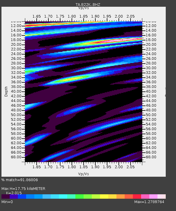
| Estimated Moho Depth: |
17.75 km |
| Estimated Crust Vp/Vs: |
2.02 |
| Assumed Crust Vp: |
5.738 km/s |
| Estimated Crust Vs: |
2.848 km/s |
| Estimated Crust Poisson's Ratio: |
0.34 |
|
| Radial Match: |
91.86806 % |
| Radial Bump: |
400 |
| Transverse Match: |
69.877304 % |
| Transverse Bump: |
400 |
| SOD ConfigId: |
21166931 |
| Insert Time: |
2020-05-29 11:14:47.346 +0000 |
| GWidth: |
2.5 |
| Max Bumps: |
400 |
| Tol: |
0.001 |
|
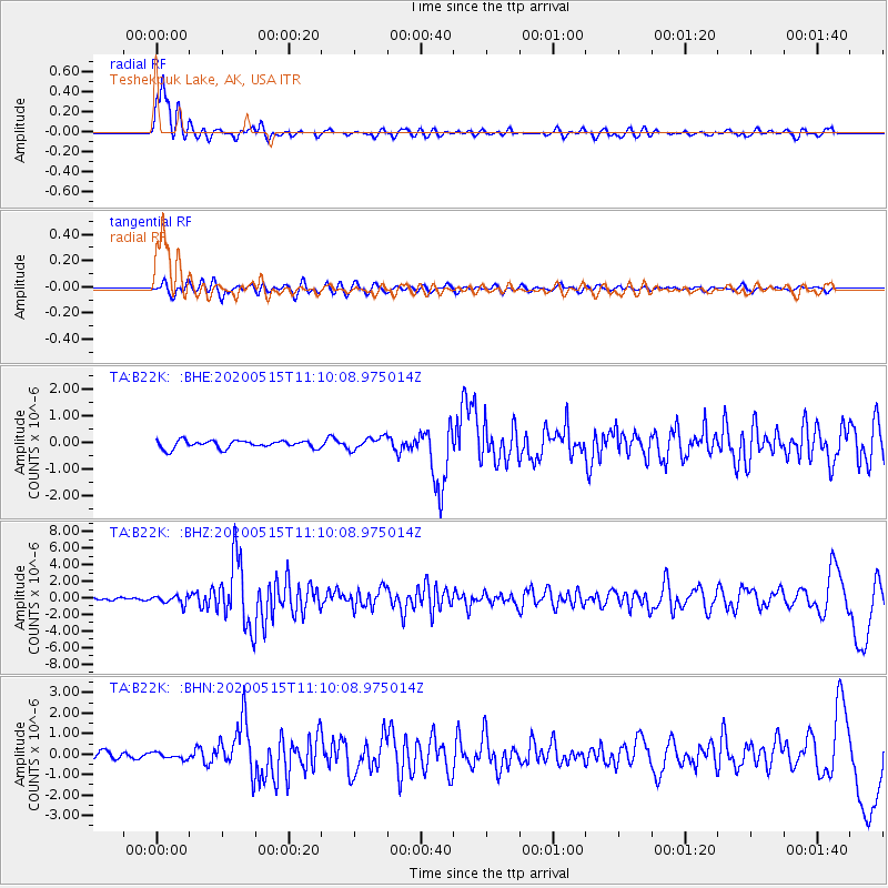
Signal To Noise
| Channel | StoN | STA | LTA |
| TA:B22K: :BHZ:20200515T11:10:08.975014Z | 2.779566 | 5.096977E-7 | 1.8337313E-7 |
| TA:B22K: :BHN:20200515T11:10:08.975014Z | 0.8999844 | 1.5803869E-7 | 1.7560157E-7 |
| TA:B22K: :BHE:20200515T11:10:08.975014Z | 1.6340944 | 2.3715145E-7 | 1.4512715E-7 |
| Arrivals |
| Ps | 3.3 SECOND |
| PpPs | 8.9 SECOND |
| PsPs/PpSs | 12 SECOND |


