You are here: Home > Network List > TA - USArray Transportable Network (new EarthScope stations) Stations List
> Station D25K Kavik River, AK, USA > Earthquake Result Viewer
D25K Kavik River, AK, USA - Earthquake Result Viewer
| Earthquake location: |
Nevada |
| Earthquake latitude/longitude: |
38.2/-117.9 |
| Earthquake time(UTC): |
2020/05/15 (136) 11:03:26 GMT |
| Earthquake Depth: |
0.4 km |
| Earthquake Magnitude: |
6.5 Mww |
| Earthquake Catalog/Contributor: |
NEIC PDE/nn |
|
| Network: |
TA USArray Transportable Network (new EarthScope stations) |
| Station: |
D25K Kavik River, AK, USA |
| Lat/Lon: |
69.32 N/146.38 W |
| Elevation: |
770 m |
|
| Distance: |
34.8 deg |
| Az: |
342.723 deg |
| Baz: |
138.769 deg |
| Ray Param: |
0.07759179 |
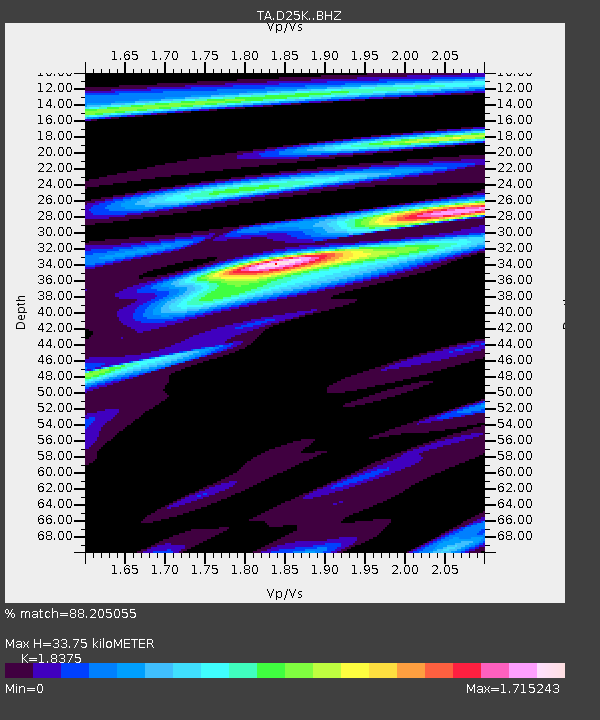
| Estimated Moho Depth: |
33.75 km |
| Estimated Crust Vp/Vs: |
1.84 |
| Assumed Crust Vp: |
6.378 km/s |
| Estimated Crust Vs: |
3.471 km/s |
| Estimated Crust Poisson's Ratio: |
0.29 |
|
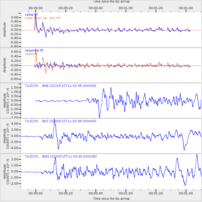
| Radial Match: |
88.205055 % |
| Radial Bump: |
400 |
| Transverse Match: |
76.76725 % |
| Transverse Bump: |
400 |
| SOD ConfigId: |
21166931 |
| Insert Time: |
2020-05-29 11:15:06.289 +0000 |
| GWidth: |
2.5 |
| Max Bumps: |
400 |
| Tol: |
0.001 |
|
Signal To Noise
| Channel | StoN | STA | LTA |
| TA:D25K: :BHZ:20200515T11:09:48.000008Z | 4.708197 | 3.3548056E-7 | 7.125457E-8 |
| TA:D25K: :BHN:20200515T11:09:48.000008Z | 1.6021161 | 9.696113E-8 | 6.052066E-8 |
| TA:D25K: :BHE:20200515T11:09:48.000008Z | 2.1677642 | 1.10813495E-7 | 5.11188E-8 |
| Arrivals |
| Ps | 4.8 SECOND |
| PpPs | 14 SECOND |
| PsPs/PpSs | 19 SECOND |


