You are here: Home > Network List > TA - USArray Transportable Network (new EarthScope stations) Stations List
> Station E21K Killik River, AK, USA > Earthquake Result Viewer
E21K Killik River, AK, USA - Earthquake Result Viewer
| Earthquake location: |
Nevada |
| Earthquake latitude/longitude: |
38.2/-117.9 |
| Earthquake time(UTC): |
2020/05/15 (136) 11:03:26 GMT |
| Earthquake Depth: |
0.4 km |
| Earthquake Magnitude: |
6.5 Mww |
| Earthquake Catalog/Contributor: |
NEIC PDE/nn |
|
| Network: |
TA USArray Transportable Network (new EarthScope stations) |
| Station: |
E21K Killik River, AK, USA |
| Lat/Lon: |
68.44 N/153.97 W |
| Elevation: |
653 m |
|
| Distance: |
36.2 deg |
| Az: |
338.358 deg |
| Baz: |
128.131 deg |
| Ray Param: |
0.07687203 |
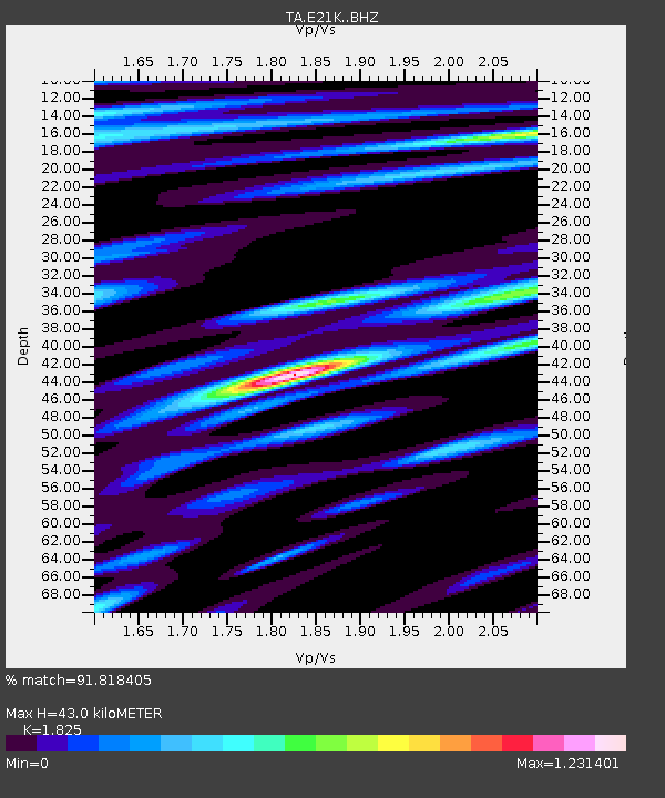
| Estimated Moho Depth: |
43.0 km |
| Estimated Crust Vp/Vs: |
1.83 |
| Assumed Crust Vp: |
6.221 km/s |
| Estimated Crust Vs: |
3.409 km/s |
| Estimated Crust Poisson's Ratio: |
0.29 |
|
| Radial Match: |
91.818405 % |
| Radial Bump: |
400 |
| Transverse Match: |
72.4941 % |
| Transverse Bump: |
400 |
| SOD ConfigId: |
21166931 |
| Insert Time: |
2020-05-29 11:15:13.650 +0000 |
| GWidth: |
2.5 |
| Max Bumps: |
400 |
| Tol: |
0.001 |
|

Signal To Noise
| Channel | StoN | STA | LTA |
| TA:E21K: :BHZ:20200515T11:09:59.94999Z | 3.3461494 | 2.813276E-7 | 8.4075026E-8 |
| TA:E21K: :BHN:20200515T11:09:59.94999Z | 1.6566563 | 9.6513716E-8 | 5.825814E-8 |
| TA:E21K: :BHE:20200515T11:09:59.94999Z | 1.720633 | 9.882644E-8 | 5.7436097E-8 |
| Arrivals |
| Ps | 6.1 SECOND |
| PpPs | 18 SECOND |
| PsPs/PpSs | 24 SECOND |


