You are here: Home > Network List > UU - University of Utah Regional Network Stations List
> Station FORU South Mineral Mountains, UT, USA > Earthquake Result Viewer
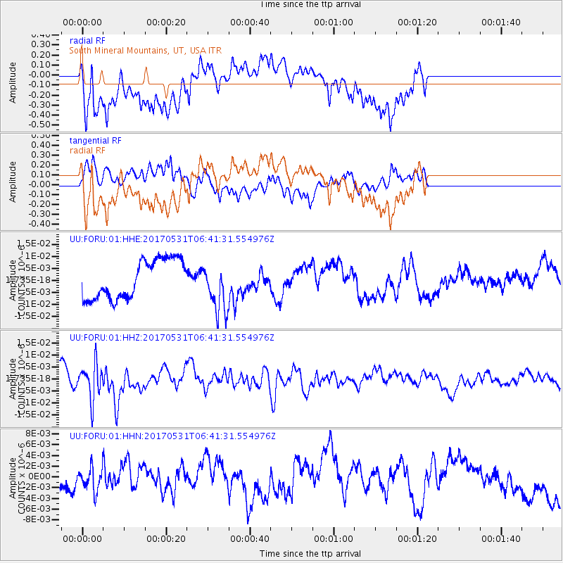
FORU South Mineral Mountains, UT, USA - Earthquake Result Viewer
*The percent match for this event was below the threshold and hence no stack was calculated.
| Earthquake location: |
Mariana Islands |
| Earthquake latitude/longitude: |
19.1/145.9 |
| Earthquake time(UTC): |
2017/05/31 (151) 06:29:32 GMT |
| Earthquake Depth: |
121 km |
| Earthquake Magnitude: |
5.4 Mww |
| Earthquake Catalog/Contributor: |
NEIC PDE/us |
|
| Network: |
UU University of Utah Regional Network |
| Station: |
FORU South Mineral Mountains, UT, USA |
| Lat/Lon: |
38.46 N/112.86 W |
| Elevation: |
1840 m |
|
| Distance: |
86.8 deg |
| Az: |
50.455 deg |
| Baz: |
291.746 deg |
| Ray Param: |
$rayparam |
*The percent match for this event was below the threshold and hence was not used in the summary stack. |
|
| Radial Match: |
60.512062 % |
| Radial Bump: |
400 |
| Transverse Match: |
49.3618 % |
| Transverse Bump: |
400 |
| SOD ConfigId: |
2140511 |
| Insert Time: |
2017-06-13 22:25:27.527 +0000 |
| GWidth: |
2.5 |
| Max Bumps: |
400 |
| Tol: |
0.001 |
|
Signal To Noise
| Channel | StoN | STA | LTA |
| UU:FORU:01:HHZ:20170531T06:41:31.554976Z | 3.0096211 | 7.3295343E-9 | 2.4353677E-9 |
| UU:FORU:01:HHN:20170531T06:41:31.554976Z | 0.92217934 | 2.1704551E-9 | 2.353615E-9 |
| UU:FORU:01:HHE:20170531T06:41:31.554976Z | 1.26697 | 1.0157951E-8 | 8.017515E-9 |
| Arrivals |
| Ps | |
| PpPs | |
| PsPs/PpSs | |


