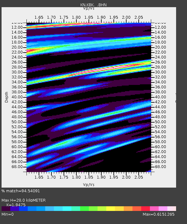
KBK KN.KBK - Earthquake Result Viewer
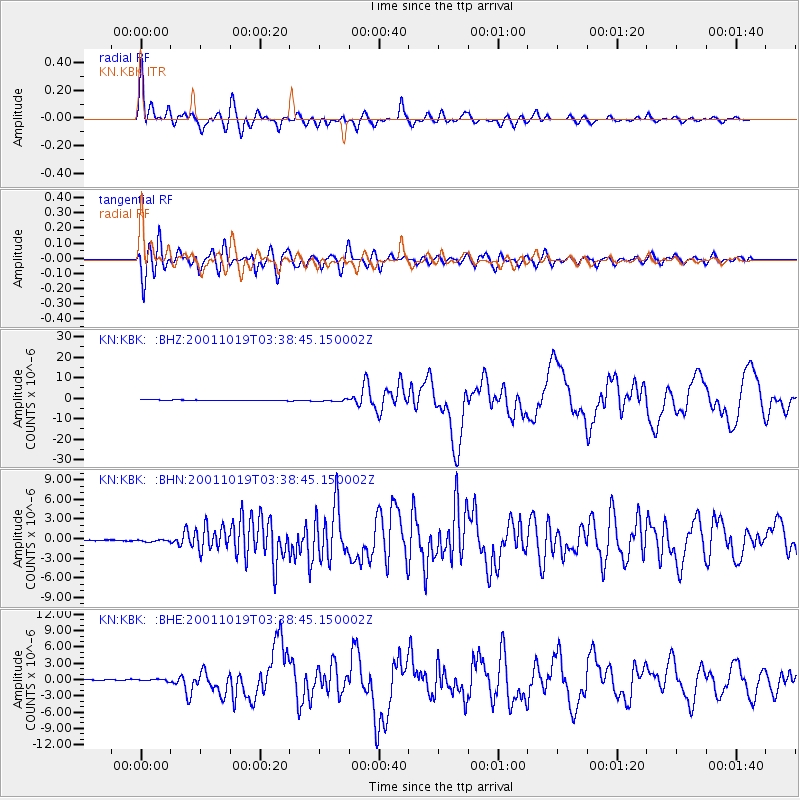
Earthquake location: Banda Sea
Earthquake latitude/longitude: -4.1/123.9
Earthquake time(UTC): 2001/10/19 (292) 03:28:44 GMT
Earthquake Depth: 33 km
Earthquake Magnitude: 6.3 MB, 7.3 MS, 7.5 MW, 7.4 MW
Earthquake Catalog/Contributor: WHDF/NEIC
Network: KN Kyrgyz Seismic Telemetry Network
Station: KBK KN.KBK
Lat/Lon: 42.66 N/74.95 E
Elevation: 1760 m
Distance: 64.2 deg
Az: 321.831 deg
Baz: 123.321 deg
Ray Param: 0.059019342
Estimated Moho Depth: 28.0 km
Estimated Crust Vp/Vs: 1.95
Assumed Crust Vp: 6.306 km/s
Estimated Crust Vs: 3.238 km/s
Estimated Crust Poisson's Ratio: 0.32
Radial Match: 94.54091 %
Radial Bump: 400
Transverse Match: 93.56484 %
Transverse Bump: 400
SOD ConfigId: 20082
Insert Time: 2010-03-08 20:05:53.226 +0000
GWidth: 2.5
Max Bumps: 400
Tol: 0.001

Signal To Noise

ChannelStoNSTALTA
KN:KBK: :BHN:20011019T03:38:45.150002Z1.71077571.3302451E-77.775684E-8
KN:KBK: :BHE:20011019T03:38:45.150002Z1.4393342.1444089E-71.4898619E-7
KN:KBK: :BHZ:20011019T03:38:45.150002Z3.47117474.7450916E-71.3669988E-7
Arrivals
Ps4.4 SECOND
PpPs13 SECOND
PsPs/PpSs17 SECOND