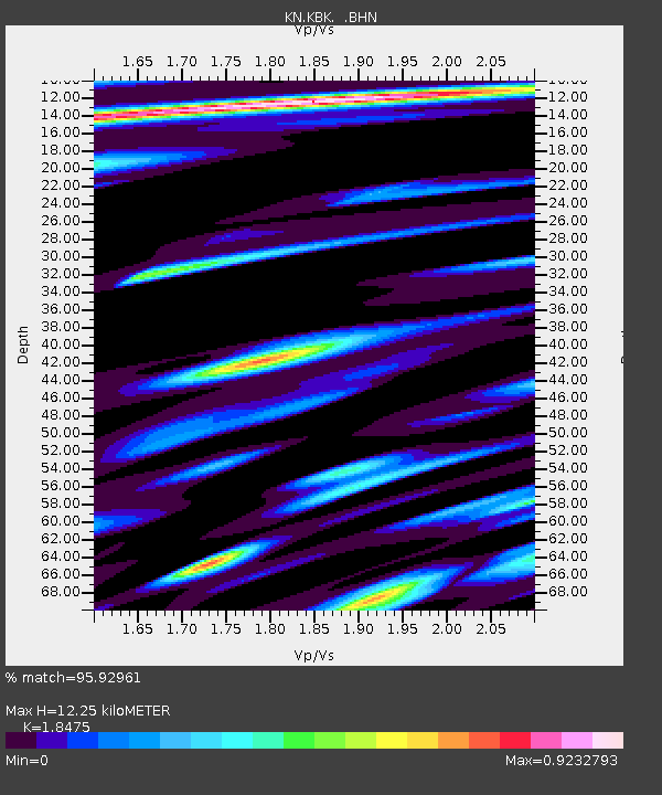
KBK KN.KBK - Earthquake Result Viewer
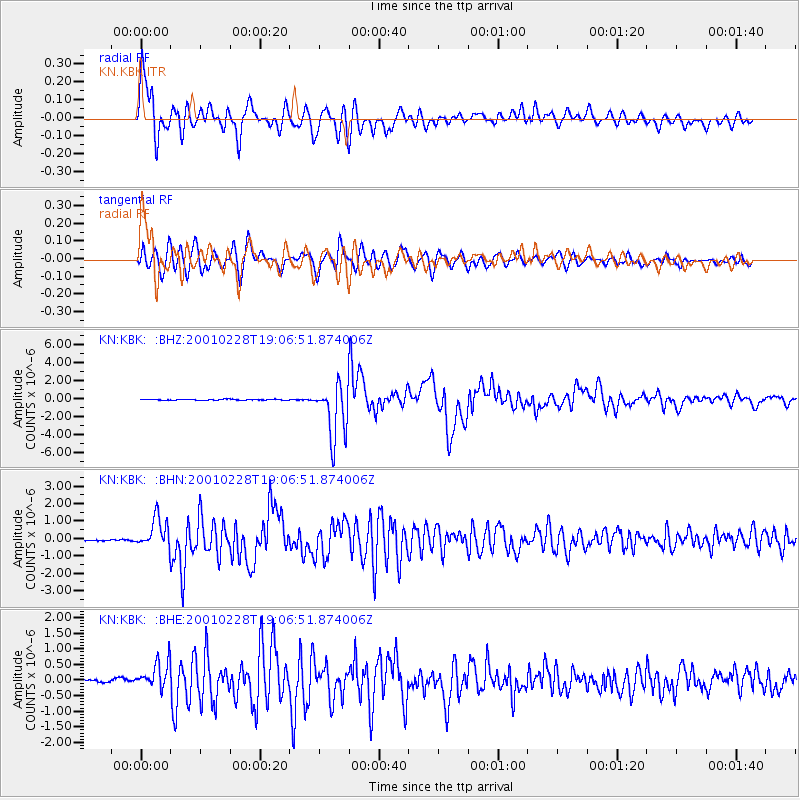
Earthquake location: Washington
Earthquake latitude/longitude: 47.1/-122.7
Earthquake time(UTC): 2001/02/28 (059) 18:54:32 GMT
Earthquake Depth: 52 km
Earthquake Magnitude: 6.5 MB, 6.6 MS, 6.8 MW, 6.7 ME
Earthquake Catalog/Contributor: WHDF/NEIC
Network: KN Kyrgyz Seismic Telemetry Network
Station: KBK KN.KBK
Lat/Lon: 42.66 N/74.95 E
Elevation: 1760 m
Distance: 89.2 deg
Az: 347.056 deg
Baz: 11.961 deg
Ray Param: 0.041926738
Estimated Moho Depth: 12.25 km
Estimated Crust Vp/Vs: 1.85
Assumed Crust Vp: 6.306 km/s
Estimated Crust Vs: 3.413 km/s
Estimated Crust Poisson's Ratio: 0.29
Radial Match: 95.92961 %
Radial Bump: 400
Transverse Match: 93.54725 %
Transverse Bump: 400
SOD ConfigId: 4714
Insert Time: 2010-03-08 20:06:01.398 +0000
GWidth: 2.5
Max Bumps: 400
Tol: 0.001

Signal To Noise

ChannelStoNSTALTA
KN:KBK: :BHN:20010228T19:06:51.874006Z9.8214888.381826E-78.53417E-8
KN:KBK: :BHE:20010228T19:06:51.874006Z7.5669344.6746152E-76.1776866E-8
KN:KBK: :BHZ:20010228T19:06:51.874006Z61.7461783.0137035E-64.8807937E-8
Arrivals
Ps1.7 SECOND
PpPs5.4 SECOND
PsPs/PpSs7.1 SECOND