KBK KN.KBK - Earthquake Result Viewer
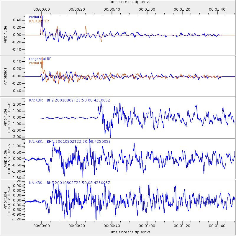
Earthquake location: Near East Coast Of Kamchatka
Earthquake latitude/longitude: 56.3/163.8
Earthquake time(UTC): 2001/08/02 (214) 23:41:06 GMT
Earthquake Depth: 14 km
Earthquake Magnitude: 5.9 MB, 6.2 MS, 6.3 MW, 6.2 ME
Earthquake Catalog/Contributor: WHDF/NEIC
Network: KN Kyrgyz Seismic Telemetry Network
Station: KBK KN.KBK
Lat/Lon: 42.66 N/74.95 E
Elevation: 1760 m
Distance: 55.3 deg
Az: 296.29 deg
Baz: 42.701 deg
Ray Param: 0.064841345
Estimated Moho Depth: 15.0 km
Estimated Crust Vp/Vs: 1.64
Assumed Crust Vp: 6.306 km/s
Estimated Crust Vs: 3.839 km/s
Estimated Crust Poisson's Ratio: 0.21
Radial Match: 95.00987 %
Radial Bump: 400
Transverse Match: 86.679016 %
Transverse Bump: 400
SOD ConfigId: 3753
Insert Time: 2010-03-08 20:06:42.727 +0000
GWidth: 2.5
Max Bumps: 400
Tol: 0.001

Signal To Noise

ChannelStoNSTALTA
KN:KBK: :BHN:20010802T23:50:08.425005Z8.1125943.6217978E-74.4644143E-8
KN:KBK: :BHE:20010802T23:50:08.425005Z6.0586493.198896E-75.2798832E-8
KN:KBK: :BHZ:20010802T23:50:08.425005Z16.0721959.322978E-75.8006876E-8
Arrivals
Ps1.6 SECOND
PpPs6.0 SECOND
PsPs/PpSs7.6 SECOND