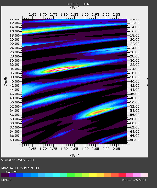
KBK KN.KBK - Earthquake Result Viewer

Earthquake location: Taiwan Region
Earthquake latitude/longitude: 24.3/122.2
Earthquake time(UTC): 2002/03/31 (090) 06:52:50 GMT
Earthquake Depth: 33 km
Earthquake Magnitude: 6.4 MB, 7.4 MS, 7.1 MW, 7.1 MW
Earthquake Catalog/Contributor: WHDF/NEIC
Network: KN Kyrgyz Seismic Telemetry Network
Station: KBK KN.KBK
Lat/Lon: 42.66 N/74.95 E
Elevation: 1760 m
Distance: 42.8 deg
Az: 307.216 deg
Baz: 99.885 deg
Ray Param: 0.07286376
Estimated Moho Depth: 33.75 km
Estimated Crust Vp/Vs: 1.79
Assumed Crust Vp: 6.306 km/s
Estimated Crust Vs: 3.523 km/s
Estimated Crust Poisson's Ratio: 0.27
Radial Match: 94.98263 %
Radial Bump: 400
Transverse Match: 91.923645 %
Transverse Bump: 400
SOD ConfigId: 20082
Insert Time: 2010-03-08 20:07:15.659 +0000
GWidth: 2.5
Max Bumps: 400
Tol: 0.001

Signal To Noise

ChannelStoNSTALTA
KN:KBK: :BHN:20020331T07:00:14.949015Z1.68816951.6233203E-79.6158615E-8
KN:KBK: :BHE:20020331T07:00:14.949015Z3.10179645.6958675E-71.8363126E-7
KN:KBK: :BHZ:20020331T07:00:14.949015Z9.8122371.6503673E-61.681948E-7
Arrivals
Ps4.5 SECOND
PpPs14 SECOND
PsPs/PpSs19 SECOND