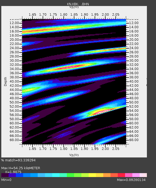
KBK KN.KBK - Earthquake Result Viewer

Earthquake location: Southwestern Ryukyu Isl., Japan
Earthquake latitude/longitude: 23.3/124.1
Earthquake time(UTC): 2002/03/26 (085) 03:45:48 GMT
Earthquake Depth: 33 km
Earthquake Magnitude: 5.8 MB, 6.6 MS, 6.4 MW, 6.4 MW
Earthquake Catalog/Contributor: WHDF/NEIC
Network: KN Kyrgyz Seismic Telemetry Network
Station: KBK KN.KBK
Lat/Lon: 42.66 N/74.95 E
Elevation: 1760 m
Distance: 44.8 deg
Az: 307.644 deg
Baz: 99.413 deg
Ray Param: 0.0716303
Estimated Moho Depth: 54.25 km
Estimated Crust Vp/Vs: 1.99
Assumed Crust Vp: 6.306 km/s
Estimated Crust Vs: 3.173 km/s
Estimated Crust Poisson's Ratio: 0.33
Radial Match: 93.339294 %
Radial Bump: 396
Transverse Match: 90.5693 %
Transverse Bump: 400
SOD ConfigId: 20082
Insert Time: 2010-03-08 20:07:17.853 +0000
GWidth: 2.5
Max Bumps: 400
Tol: 0.001

Signal To Noise

ChannelStoNSTALTA
KN:KBK: :BHN:20020326T03:53:28.825Z0.596944879.141394E-81.5313631E-7
KN:KBK: :BHE:20020326T03:53:28.825Z2.97118452.9305986E-79.863402E-8
KN:KBK: :BHZ:20020326T03:53:28.825Z10.4493865.9270735E-75.6721742E-8
Arrivals
Ps9.0 SECOND
PpPs24 SECOND
PsPs/PpSs33 SECOND