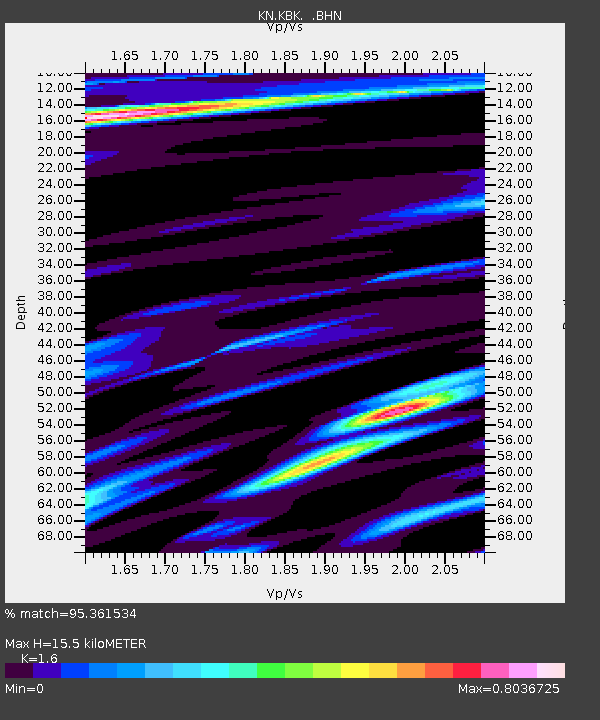
KBK KN.KBK - Earthquake Result Viewer
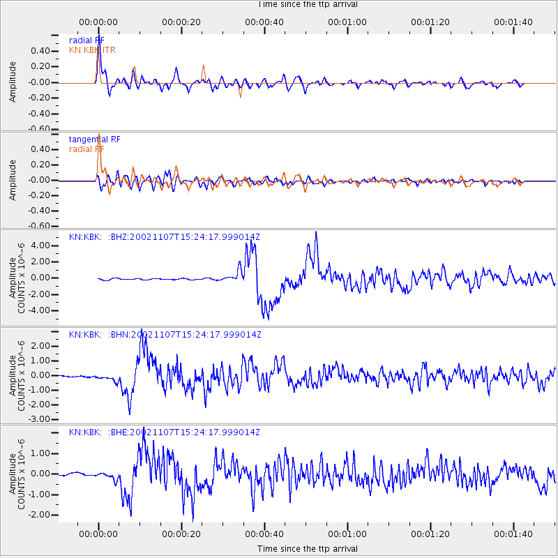
Earthquake location: Rat Islands, Aleutian Islands
Earthquake latitude/longitude: 51.2/179.3
Earthquake time(UTC): 2002/11/07 (311) 15:14:06 GMT
Earthquake Depth: 33 km
Earthquake Magnitude: 5.8 MB, 6.4 MS, 6.6 MW, 6.5 MW
Earthquake Catalog/Contributor: WHDF/NEIC
Network: KN Kyrgyz Seismic Telemetry Network
Station: KBK KN.KBK
Lat/Lon: 42.66 N/74.95 E
Elevation: 1760 m
Distance: 65.8 deg
Az: 308.444 deg
Baz: 41.915 deg
Ray Param: 0.057960767
Estimated Moho Depth: 15.5 km
Estimated Crust Vp/Vs: 1.60
Assumed Crust Vp: 6.306 km/s
Estimated Crust Vs: 3.941 km/s
Estimated Crust Poisson's Ratio: 0.18
Radial Match: 95.361534 %
Radial Bump: 400
Transverse Match: 89.84877 %
Transverse Bump: 400
SOD ConfigId: 4714
Insert Time: 2010-03-08 20:07:26.432 +0000
GWidth: 2.5
Max Bumps: 400
Tol: 0.001

Signal To Noise

ChannelStoNSTALTA
KN:KBK: :BHN:20021107T15:24:17.999014Z2.6340782.5225785E-79.5767035E-8
KN:KBK: :BHE:20021107T15:24:17.999014Z2.10102531.7377752E-78.271082E-8
KN:KBK: :BHZ:20021107T15:24:17.999014Z9.140017.5406336E-78.250137E-8
Arrivals
Ps1.5 SECOND
PpPs6.1 SECOND
PsPs/PpSs7.7 SECOND