You are here: Home > Network List > TS - TERRAscope (Southern California Seismic Network) Stations List
> Station SMTC Superstition Mountain, California, USA > Earthquake Result Viewer
SMTC Superstition Mountain, California, USA - Earthquake Result Viewer
| Earthquake location: |
Vanuatu Islands |
| Earthquake latitude/longitude: |
-18.8/169.2 |
| Earthquake time(UTC): |
1994/02/11 (042) 21:17:31 GMT |
| Earthquake Depth: |
204 km |
| Earthquake Magnitude: |
6.3 MB, 7.0 UNKNOWN, 6.8 MW |
| Earthquake Catalog/Contributor: |
WHDF/NEIC |
|
| Network: |
TS TERRAscope (Southern California Seismic Network) |
| Station: |
SMTC Superstition Mountain, California, USA |
| Lat/Lon: |
32.95 N/115.72 W |
| Elevation: |
-50.0 m |
|
| Distance: |
88.2 deg |
| Az: |
54.391 deg |
| Baz: |
246.336 deg |
| Ray Param: |
0.04227193 |
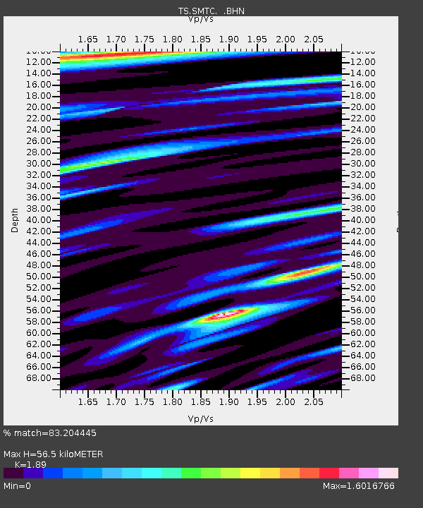
| Estimated Moho Depth: |
56.5 km |
| Estimated Crust Vp/Vs: |
1.89 |
| Assumed Crust Vp: |
6.155 km/s |
| Estimated Crust Vs: |
3.256 km/s |
| Estimated Crust Poisson's Ratio: |
0.31 |
|
| Radial Match: |
83.204445 % |
| Radial Bump: |
375 |
| Transverse Match: |
79.24319 % |
| Transverse Bump: |
400 |
| SOD ConfigId: |
16938 |
| Insert Time: |
2010-02-26 14:50:22.268 +0000 |
| GWidth: |
2.5 |
| Max Bumps: |
400 |
| Tol: |
0.001 |
|
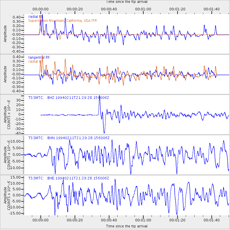
Signal To Noise
| Channel | StoN | STA | LTA |
| TS:SMTC: :BHN:19940211T21:29:28.156006Z | 1.9256988 | 1.4396182E-6 | 7.4758225E-7 |
| TS:SMTC: :BHE:19940211T21:29:28.156006Z | 2.1330724 | 2.1060885E-6 | 9.873497E-7 |
| TS:SMTC: :BHZ:19940211T21:29:28.156006Z | 25.967125 | 1.2426604E-5 | 4.785514E-7 |
| Arrivals |
| Ps | 8.3 SECOND |
| PpPs | 26 SECOND |
| PsPs/PpSs | 34 SECOND |


