You are here: Home > Network List > TA - USArray Transportable Network (new EarthScope stations) Stations List
> Station D25K Kavik River, AK, USA > Earthquake Result Viewer
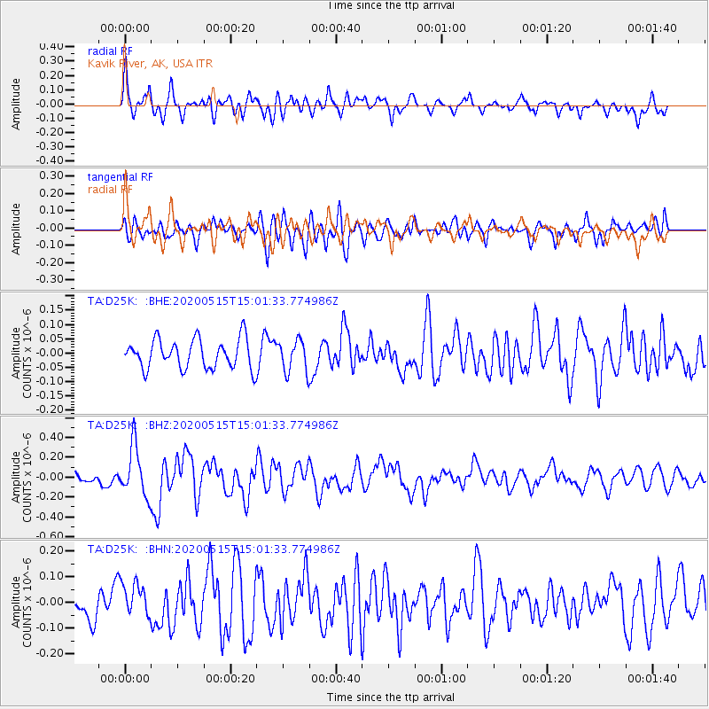
D25K Kavik River, AK, USA - Earthquake Result Viewer
*The percent match for this event was below the threshold and hence no stack was calculated.
| Earthquake location: |
Samoa Islands Region |
| Earthquake latitude/longitude: |
-15.6/-173.0 |
| Earthquake time(UTC): |
2020/05/15 (136) 14:49:21 GMT |
| Earthquake Depth: |
16 km |
| Earthquake Magnitude: |
5.8 mww |
| Earthquake Catalog/Contributor: |
NEIC PDE/us |
|
| Network: |
TA USArray Transportable Network (new EarthScope stations) |
| Station: |
D25K Kavik River, AK, USA |
| Lat/Lon: |
69.32 N/146.38 W |
| Elevation: |
770 m |
|
| Distance: |
86.8 deg |
| Az: |
9.165 deg |
| Baz: |
205.601 deg |
| Ray Param: |
$rayparam |
*The percent match for this event was below the threshold and hence was not used in the summary stack. |
|
| Radial Match: |
63.198185 % |
| Radial Bump: |
400 |
| Transverse Match: |
65.72425 % |
| Transverse Bump: |
400 |
| SOD ConfigId: |
21166931 |
| Insert Time: |
2020-05-29 15:06:18.176 +0000 |
| GWidth: |
2.5 |
| Max Bumps: |
400 |
| Tol: |
0.001 |
|
Signal To Noise
| Channel | StoN | STA | LTA |
| TA:D25K: :BHZ:20200515T15:01:33.774986Z | 5.0494404 | 2.5530508E-7 | 5.0561066E-8 |
| TA:D25K: :BHN:20200515T15:01:33.774986Z | 1.0916278 | 6.771652E-8 | 6.2032605E-8 |
| TA:D25K: :BHE:20200515T15:01:33.774986Z | 1.1057509 | 5.647269E-8 | 5.10718E-8 |
| Arrivals |
| Ps | |
| PpPs | |
| PsPs/PpSs | |


