You are here: Home > Network List > TA - USArray Transportable Network (new EarthScope stations) Stations List
> Station F20K Avaraart Lake, AK, USA > Earthquake Result Viewer
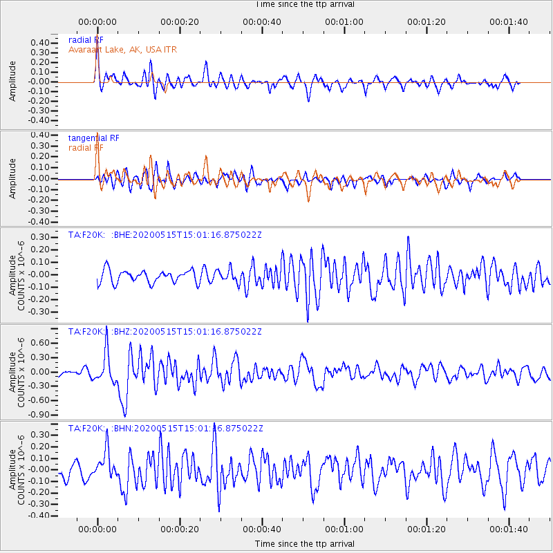
F20K Avaraart Lake, AK, USA - Earthquake Result Viewer
*The percent match for this event was below the threshold and hence no stack was calculated.
| Earthquake location: |
Samoa Islands Region |
| Earthquake latitude/longitude: |
-15.6/-173.0 |
| Earthquake time(UTC): |
2020/05/15 (136) 14:49:21 GMT |
| Earthquake Depth: |
16 km |
| Earthquake Magnitude: |
5.8 mww |
| Earthquake Catalog/Contributor: |
NEIC PDE/us |
|
| Network: |
TA USArray Transportable Network (new EarthScope stations) |
| Station: |
F20K Avaraart Lake, AK, USA |
| Lat/Lon: |
67.05 N/155.73 W |
| Elevation: |
136 m |
|
| Distance: |
83.4 deg |
| Az: |
6.722 deg |
| Baz: |
196.715 deg |
| Ray Param: |
$rayparam |
*The percent match for this event was below the threshold and hence was not used in the summary stack. |
|
| Radial Match: |
77.51974 % |
| Radial Bump: |
400 |
| Transverse Match: |
70.976746 % |
| Transverse Bump: |
400 |
| SOD ConfigId: |
21166931 |
| Insert Time: |
2020-05-29 15:06:43.324 +0000 |
| GWidth: |
2.5 |
| Max Bumps: |
400 |
| Tol: |
0.001 |
|
Signal To Noise
| Channel | StoN | STA | LTA |
| TA:F20K: :BHZ:20200515T15:01:16.875022Z | 5.445236 | 3.3037935E-7 | 6.0673095E-8 |
| TA:F20K: :BHN:20200515T15:01:16.875022Z | 2.6681924 | 1.2632972E-7 | 4.7346553E-8 |
| TA:F20K: :BHE:20200515T15:01:16.875022Z | 1.0292261 | 5.13337E-8 | 4.9876018E-8 |
| Arrivals |
| Ps | |
| PpPs | |
| PsPs/PpSs | |


