You are here: Home > Network List > TA - USArray Transportable Network (new EarthScope stations) Stations List
> Station F21K Alatna River, AK, USA > Earthquake Result Viewer
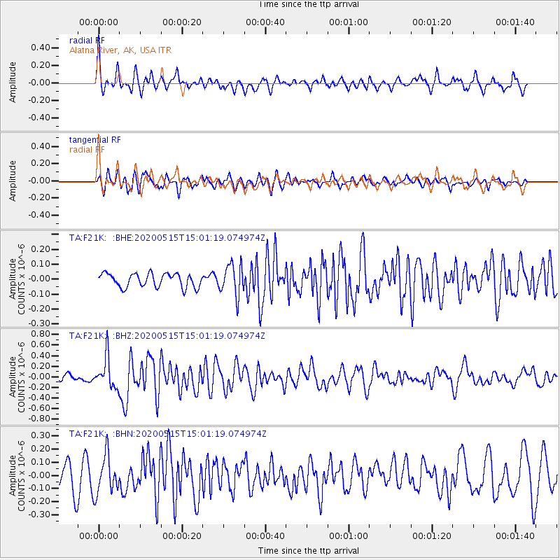
F21K Alatna River, AK, USA - Earthquake Result Viewer
*The percent match for this event was below the threshold and hence no stack was calculated.
| Earthquake location: |
Samoa Islands Region |
| Earthquake latitude/longitude: |
-15.6/-173.0 |
| Earthquake time(UTC): |
2020/05/15 (136) 14:49:21 GMT |
| Earthquake Depth: |
16 km |
| Earthquake Magnitude: |
5.8 mww |
| Earthquake Catalog/Contributor: |
NEIC PDE/us |
|
| Network: |
TA USArray Transportable Network (new EarthScope stations) |
| Station: |
F21K Alatna River, AK, USA |
| Lat/Lon: |
67.22 N/153.48 W |
| Elevation: |
597 m |
|
| Distance: |
83.8 deg |
| Az: |
7.508 deg |
| Baz: |
198.866 deg |
| Ray Param: |
$rayparam |
*The percent match for this event was below the threshold and hence was not used in the summary stack. |
|
| Radial Match: |
67.5176 % |
| Radial Bump: |
400 |
| Transverse Match: |
77.538956 % |
| Transverse Bump: |
400 |
| SOD ConfigId: |
21166931 |
| Insert Time: |
2020-05-29 15:06:45.405 +0000 |
| GWidth: |
2.5 |
| Max Bumps: |
400 |
| Tol: |
0.001 |
|
Signal To Noise
| Channel | StoN | STA | LTA |
| TA:F21K: :BHZ:20200515T15:01:19.074974Z | 5.070651 | 2.985133E-7 | 5.8870803E-8 |
| TA:F21K: :BHN:20200515T15:01:19.074974Z | 1.6204801 | 1.4382269E-7 | 8.875314E-8 |
| TA:F21K: :BHE:20200515T15:01:19.074974Z | 2.328997 | 1.06454834E-7 | 4.5708447E-8 |
| Arrivals |
| Ps | |
| PpPs | |
| PsPs/PpSs | |


