You are here: Home > Network List > TA - USArray Transportable Network (new EarthScope stations) Stations List
> Station H16K Elim, AK, USA > Earthquake Result Viewer
H16K Elim, AK, USA - Earthquake Result Viewer
| Earthquake location: |
Samoa Islands Region |
| Earthquake latitude/longitude: |
-15.6/-173.0 |
| Earthquake time(UTC): |
2020/05/15 (136) 14:49:21 GMT |
| Earthquake Depth: |
16 km |
| Earthquake Magnitude: |
5.8 mww |
| Earthquake Catalog/Contributor: |
NEIC PDE/us |
|
| Network: |
TA USArray Transportable Network (new EarthScope stations) |
| Station: |
H16K Elim, AK, USA |
| Lat/Lon: |
64.64 N/162.24 W |
| Elevation: |
216 m |
|
| Distance: |
80.4 deg |
| Az: |
4.666 deg |
| Baz: |
190.487 deg |
| Ray Param: |
0.048277628 |
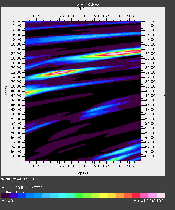
| Estimated Moho Depth: |
23.5 km |
| Estimated Crust Vp/Vs: |
2.01 |
| Assumed Crust Vp: |
6.276 km/s |
| Estimated Crust Vs: |
3.126 km/s |
| Estimated Crust Poisson's Ratio: |
0.33 |
|
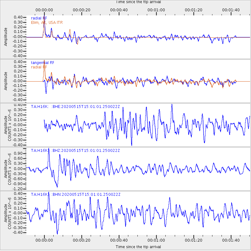
| Radial Match: |
80.98702 % |
| Radial Bump: |
400 |
| Transverse Match: |
80.12024 % |
| Transverse Bump: |
400 |
| SOD ConfigId: |
21166931 |
| Insert Time: |
2020-05-29 15:07:12.396 +0000 |
| GWidth: |
2.5 |
| Max Bumps: |
400 |
| Tol: |
0.001 |
|
Signal To Noise
| Channel | StoN | STA | LTA |
| TA:H16K: :BHZ:20200515T15:01:01.250022Z | 6.4583807 | 4.0282785E-7 | 6.237289E-8 |
| TA:H16K: :BHN:20200515T15:01:01.250022Z | 2.433344 | 1.5229071E-7 | 6.258495E-8 |
| TA:H16K: :BHE:20200515T15:01:01.250022Z | 2.175858 | 1.3138838E-7 | 6.038463E-8 |
| Arrivals |
| Ps | 3.9 SECOND |
| PpPs | 11 SECOND |
| PsPs/PpSs | 15 SECOND |


