You are here: Home > Network List > BK - Berkeley Digital Seismograph Network Stations List
> Station HUMO Hull Mountain, OR > Earthquake Result Viewer
HUMO Hull Mountain, OR - Earthquake Result Viewer
| Earthquake location: |
Near Islands, Aleutian Islands |
| Earthquake latitude/longitude: |
54.0/170.9 |
| Earthquake time(UTC): |
2017/06/02 (153) 22:24:47 GMT |
| Earthquake Depth: |
8.2 km |
| Earthquake Magnitude: |
6.8 Mww |
| Earthquake Catalog/Contributor: |
NEIC PDE/us |
|
| Network: |
BK Berkeley Digital Seismograph Network |
| Station: |
HUMO Hull Mountain, OR |
| Lat/Lon: |
42.61 N/122.96 W |
| Elevation: |
555 m |
|
| Distance: |
43.9 deg |
| Az: |
76.93 deg |
| Baz: |
308.885 deg |
| Ray Param: |
0.07227201 |
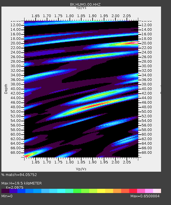
| Estimated Moho Depth: |
19.5 km |
| Estimated Crust Vp/Vs: |
2.10 |
| Assumed Crust Vp: |
6.522 km/s |
| Estimated Crust Vs: |
3.109 km/s |
| Estimated Crust Poisson's Ratio: |
0.35 |
|
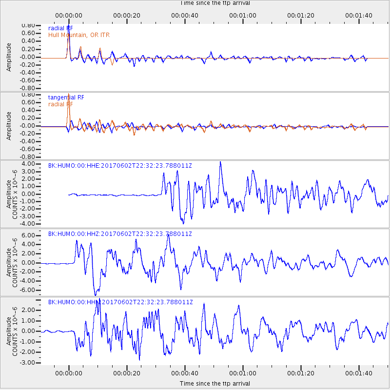
| Radial Match: |
94.05752 % |
| Radial Bump: |
393 |
| Transverse Match: |
83.905396 % |
| Transverse Bump: |
400 |
| SOD ConfigId: |
2140511 |
| Insert Time: |
2017-06-16 14:18:03.444 +0000 |
| GWidth: |
2.5 |
| Max Bumps: |
400 |
| Tol: |
0.001 |
|
Signal To Noise
| Channel | StoN | STA | LTA |
| BK:HUMO:00:HHZ:20170602T22:32:23.788011Z | 24.94451 | 2.3101645E-6 | 9.261214E-8 |
| BK:HUMO:00:HHN:20170602T22:32:23.788011Z | 12.409406 | 8.0826686E-7 | 6.51334E-8 |
| BK:HUMO:00:HHE:20170602T22:32:23.788011Z | 20.0381 | 1.1345629E-6 | 5.6620284E-8 |
| Arrivals |
| Ps | 3.5 SECOND |
| PpPs | 8.7 SECOND |
| PsPs/PpSs | 12 SECOND |


