You are here: Home > Network List > TA - USArray Transportable Network (new EarthScope stations) Stations List
> Station O17K Koliganek, Bristol Bay, AK, USA > Earthquake Result Viewer
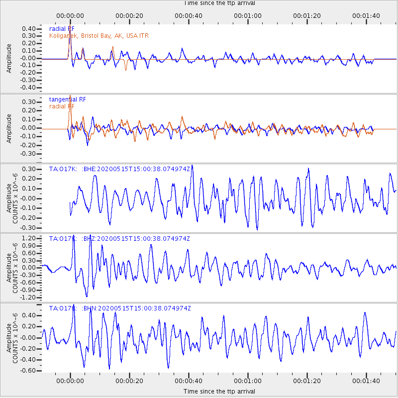
O17K Koliganek, Bristol Bay, AK, USA - Earthquake Result Viewer
*The percent match for this event was below the threshold and hence no stack was calculated.
| Earthquake location: |
Samoa Islands Region |
| Earthquake latitude/longitude: |
-15.6/-173.0 |
| Earthquake time(UTC): |
2020/05/15 (136) 14:49:21 GMT |
| Earthquake Depth: |
16 km |
| Earthquake Magnitude: |
5.8 mww |
| Earthquake Catalog/Contributor: |
NEIC PDE/us |
|
| Network: |
TA USArray Transportable Network (new EarthScope stations) |
| Station: |
O17K Koliganek, Bristol Bay, AK, USA |
| Lat/Lon: |
59.77 N/157.09 W |
| Elevation: |
156 m |
|
| Distance: |
76.2 deg |
| Az: |
8.194 deg |
| Baz: |
195.751 deg |
| Ray Param: |
$rayparam |
*The percent match for this event was below the threshold and hence was not used in the summary stack. |
|
| Radial Match: |
61.884212 % |
| Radial Bump: |
400 |
| Transverse Match: |
63.799107 % |
| Transverse Bump: |
393 |
| SOD ConfigId: |
21166931 |
| Insert Time: |
2020-05-29 15:08:14.595 +0000 |
| GWidth: |
2.5 |
| Max Bumps: |
400 |
| Tol: |
0.001 |
|
Signal To Noise
| Channel | StoN | STA | LTA |
| TA:O17K: :BHZ:20200515T15:00:38.074974Z | 3.0139825 | 4.927683E-7 | 1.6349408E-7 |
| TA:O17K: :BHN:20200515T15:00:38.074974Z | 2.5265174 | 2.7765898E-7 | 1.0989791E-7 |
| TA:O17K: :BHE:20200515T15:00:38.074974Z | 1.1959094 | 1.2355817E-7 | 1.03317326E-7 |
| Arrivals |
| Ps | |
| PpPs | |
| PsPs/PpSs | |


