You are here: Home > Network List > KN - Kyrgyz Seismic Telemetry Network Stations List
> Station KBK KN.KBK > Earthquake Result Viewer
KBK KN.KBK - Earthquake Result Viewer

| Earthquake location: |
Mindoro, Philippines |
| Earthquake latitude/longitude: |
13.9/120.5 |
| Earthquake time(UTC): |
2004/10/08 (282) 14:36:06 GMT |
| Earthquake Depth: |
105 km |
| Earthquake Magnitude: |
6.3 MB, 6.5 MW, 6.4 MW |
| Earthquake Catalog/Contributor: |
WHDF/NEIC |
|
| Network: |
KN Kyrgyz Seismic Telemetry Network |
| Station: |
KBK KN.KBK |
| Lat/Lon: |
42.66 N/74.95 E |
| Elevation: |
1760 m |
|
| Distance: |
48.5 deg |
| Az: |
315.279 deg |
| Baz: |
112.152 deg |
| Ray Param: |
0.068965994 |
| Estimated Moho Depth: |
34.5 km |
| Estimated Crust Vp/Vs: |
1.63 |
| Assumed Crust Vp: |
6.306 km/s |
| Estimated Crust Vs: |
3.875 km/s |
| Estimated Crust Poisson's Ratio: |
0.20 |
|
| Radial Match: |
92.90615 % |
| Radial Bump: |
400 |
| Transverse Match: |
93.09804 % |
| Transverse Bump: |
400 |
| SOD ConfigId: |
2459 |
| Insert Time: |
2010-03-08 20:09:02.827 +0000 |
| GWidth: |
2.5 |
| Max Bumps: |
400 |
| Tol: |
0.001 |
|
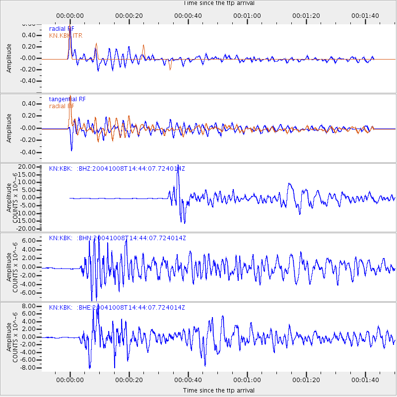
Signal To Noise
| Channel | StoN | STA | LTA |
| KN:KBK: :BHN:20041008T14:44:07.724014Z | 5.750807 | 4.9123685E-7 | 8.542051E-8 |
| KN:KBK: :BHE:20041008T14:44:07.724014Z | 4.9151 | 5.2154996E-7 | 1.0611176E-7 |
| KN:KBK: :BHZ:20041008T14:44:07.724014Z | 18.496624 | 1.5150654E-6 | 8.191038E-8 |
| Arrivals |
| Ps | 3.7 SECOND |
| PpPs | 14 SECOND |
| PsPs/PpSs | 17 SECOND |


