You are here: Home > Network List > UW - Pacific Northwest Regional Seismic Network Stations List
> Station UMAT Pilot Rock, OR, USA > Earthquake Result Viewer
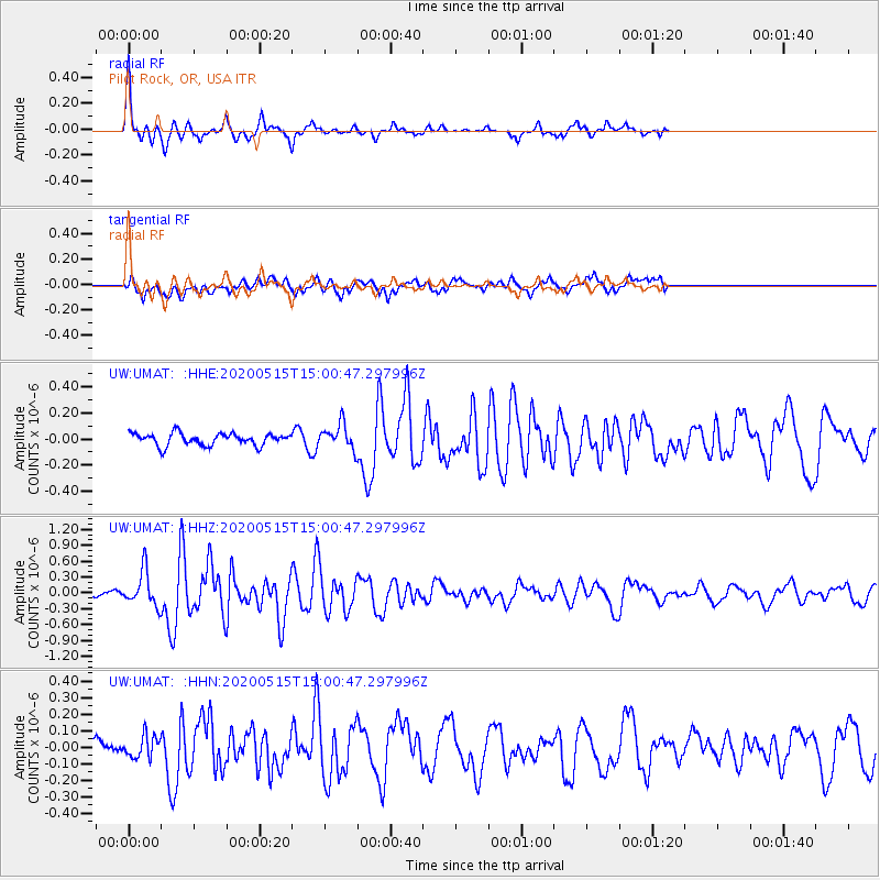
UMAT Pilot Rock, OR, USA - Earthquake Result Viewer
*The percent match for this event was below the threshold and hence no stack was calculated.
| Earthquake location: |
Samoa Islands Region |
| Earthquake latitude/longitude: |
-15.6/-173.0 |
| Earthquake time(UTC): |
2020/05/15 (136) 14:49:21 GMT |
| Earthquake Depth: |
16 km |
| Earthquake Magnitude: |
5.8 mww |
| Earthquake Catalog/Contributor: |
NEIC PDE/us |
|
| Network: |
UW Pacific Northwest Regional Seismic Network |
| Station: |
UMAT Pilot Rock, OR, USA |
| Lat/Lon: |
45.29 N/118.96 W |
| Elevation: |
1318 m |
|
| Distance: |
77.9 deg |
| Az: |
35.749 deg |
| Baz: |
232.892 deg |
| Ray Param: |
$rayparam |
*The percent match for this event was below the threshold and hence was not used in the summary stack. |
|
| Radial Match: |
75.75656 % |
| Radial Bump: |
262 |
| Transverse Match: |
70.72587 % |
| Transverse Bump: |
400 |
| SOD ConfigId: |
21166931 |
| Insert Time: |
2020-05-29 15:12:14.166 +0000 |
| GWidth: |
2.5 |
| Max Bumps: |
400 |
| Tol: |
0.001 |
|
Signal To Noise
| Channel | StoN | STA | LTA |
| UW:UMAT: :HHZ:20200515T15:00:47.297996Z | 5.3951406 | 3.249884E-7 | 6.023725E-8 |
| UW:UMAT: :HHN:20200515T15:00:47.297996Z | 0.9888469 | 6.540222E-8 | 6.613988E-8 |
| UW:UMAT: :HHE:20200515T15:00:47.297996Z | 1.9899586 | 9.34395E-8 | 4.69555E-8 |
| Arrivals |
| Ps | |
| PpPs | |
| PsPs/PpSs | |


