You are here: Home > Network List > WY - Yellowstone Wyoming Seismic Network Stations List
> Station YHH Holmes Hill, YNP, WY, USA > Earthquake Result Viewer
YHH Holmes Hill, YNP, WY, USA - Earthquake Result Viewer
| Earthquake location: |
Samoa Islands Region |
| Earthquake latitude/longitude: |
-15.6/-173.0 |
| Earthquake time(UTC): |
2020/05/15 (136) 14:49:21 GMT |
| Earthquake Depth: |
16 km |
| Earthquake Magnitude: |
5.8 mww |
| Earthquake Catalog/Contributor: |
NEIC PDE/us |
|
| Network: |
WY Yellowstone Wyoming Seismic Network |
| Station: |
YHH Holmes Hill, YNP, WY, USA |
| Lat/Lon: |
44.79 N/110.85 W |
| Elevation: |
2717 m |
|
| Distance: |
82.4 deg |
| Az: |
39.426 deg |
| Baz: |
239.248 deg |
| Ray Param: |
0.046937067 |
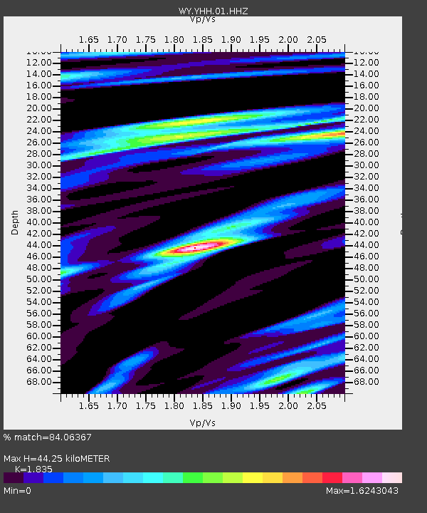
| Estimated Moho Depth: |
44.25 km |
| Estimated Crust Vp/Vs: |
1.84 |
| Assumed Crust Vp: |
6.35 km/s |
| Estimated Crust Vs: |
3.46 km/s |
| Estimated Crust Poisson's Ratio: |
0.29 |
|
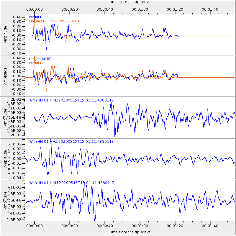
| Radial Match: |
84.06367 % |
| Radial Bump: |
390 |
| Transverse Match: |
80.66549 % |
| Transverse Bump: |
400 |
| SOD ConfigId: |
21166931 |
| Insert Time: |
2020-05-29 15:12:23.326 +0000 |
| GWidth: |
2.5 |
| Max Bumps: |
400 |
| Tol: |
0.001 |
|
Signal To Noise
| Channel | StoN | STA | LTA |
| WY:YHH:01:HHZ:20200515T15:01:11.438011Z | 3.658512 | 9.185022E-9 | 2.5105893E-9 |
| WY:YHH:01:HHN:20200515T15:01:11.438011Z | 1.3899964 | 2.6977274E-9 | 1.9408162E-9 |
| WY:YHH:01:HHE:20200515T15:01:11.438011Z | 1.204954 | 2.695832E-9 | 2.2372904E-9 |
| Arrivals |
| Ps | 6.0 SECOND |
| PpPs | 19 SECOND |
| PsPs/PpSs | 25 SECOND |


