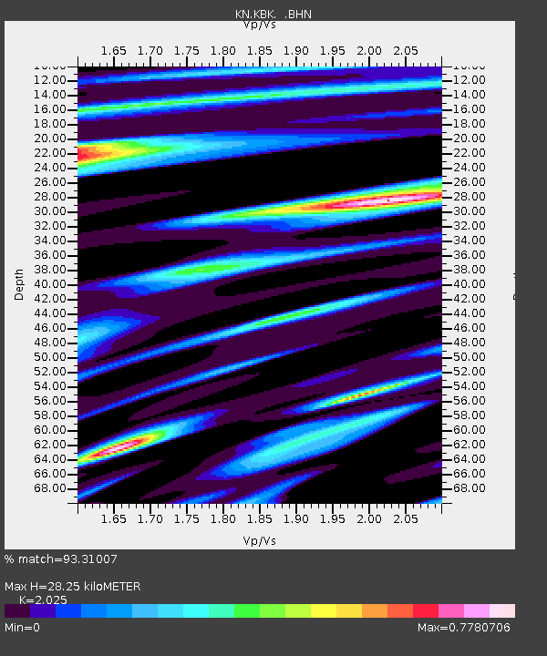
KBK KN.KBK - Earthquake Result Viewer

Earthquake location: Irian Jaya Region, Indonesia
Earthquake latitude/longitude: -3.7/135.3
Earthquake time(UTC): 2004/02/08 (039) 08:58:51 GMT
Earthquake Depth: 26 km
Earthquake Magnitude: 5.7 MB, 6.9 MS, 6.7 MW, 6.5 MW
Earthquake Catalog/Contributor: WHDF/NEIC
Network: KN Kyrgyz Seismic Telemetry Network
Station: KBK KN.KBK
Lat/Lon: 42.66 N/74.95 E
Elevation: 1760 m
Distance: 71.3 deg
Az: 317.377 deg
Baz: 113.637 deg
Ray Param: 0.05439789
Estimated Moho Depth: 28.25 km
Estimated Crust Vp/Vs: 2.03
Assumed Crust Vp: 6.306 km/s
Estimated Crust Vs: 3.114 km/s
Estimated Crust Poisson's Ratio: 0.34
Radial Match: 93.31007 %
Radial Bump: 400
Transverse Match: 83.13891 %
Transverse Bump: 400
SOD ConfigId: 2459
Insert Time: 2010-03-08 20:09:34.888 +0000
GWidth: 2.5
Max Bumps: 400
Tol: 0.001

Signal To Noise

ChannelStoNSTALTA
KN:KBK: :BHN:20040208T09:09:37.800Z0.611505456.041998E-89.8805295E-8
KN:KBK: :BHE:20040208T09:09:37.800Z2.30218891.3330889E-75.7905282E-8
KN:KBK: :BHZ:20040208T09:09:37.800Z8.4564433.8781295E-74.5860055E-8
Arrivals
Ps4.7 SECOND
PpPs13 SECOND
PsPs/PpSs18 SECOND