You are here: Home > Network List > G - GEOSCOPE Stations List
> Station IVI Ivittuut, Greenland > Earthquake Result Viewer
IVI Ivittuut, Greenland - Earthquake Result Viewer
| Earthquake location: |
Near Islands, Aleutian Islands |
| Earthquake latitude/longitude: |
54.0/170.9 |
| Earthquake time(UTC): |
2017/06/02 (153) 22:24:47 GMT |
| Earthquake Depth: |
8.2 km |
| Earthquake Magnitude: |
6.8 Mww |
| Earthquake Catalog/Contributor: |
NEIC PDE/us |
|
| Network: |
G GEOSCOPE |
| Station: |
IVI Ivittuut, Greenland |
| Lat/Lon: |
61.21 N/48.17 W |
| Elevation: |
15 m |
|
| Distance: |
61.0 deg |
| Az: |
20.424 deg |
| Baz: |
334.835 deg |
| Ray Param: |
0.061163206 |
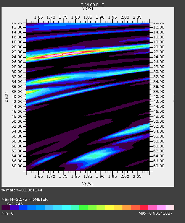
| Estimated Moho Depth: |
22.75 km |
| Estimated Crust Vp/Vs: |
1.75 |
| Assumed Crust Vp: |
6.472 km/s |
| Estimated Crust Vs: |
3.709 km/s |
| Estimated Crust Poisson's Ratio: |
0.26 |
|
| Radial Match: |
80.361244 % |
| Radial Bump: |
400 |
| Transverse Match: |
70.403305 % |
| Transverse Bump: |
400 |
| SOD ConfigId: |
2140511 |
| Insert Time: |
2017-06-16 14:20:12.333 +0000 |
| GWidth: |
2.5 |
| Max Bumps: |
400 |
| Tol: |
0.001 |
|

Signal To Noise
| Channel | StoN | STA | LTA |
| G:IVI:00:BHZ:20170602T22:34:30.599016Z | 3.623771 | 1.9763038E-6 | 5.4537213E-7 |
| G:IVI:00:BHN:20170602T22:34:30.599016Z | 0.79757947 | 6.64979E-7 | 8.337464E-7 |
| G:IVI:00:BHE:20170602T22:34:30.599016Z | 1.1214164 | 4.349616E-7 | 3.8786806E-7 |
| Arrivals |
| Ps | 2.7 SECOND |
| PpPs | 9.2 SECOND |
| PsPs/PpSs | 12 SECOND |


