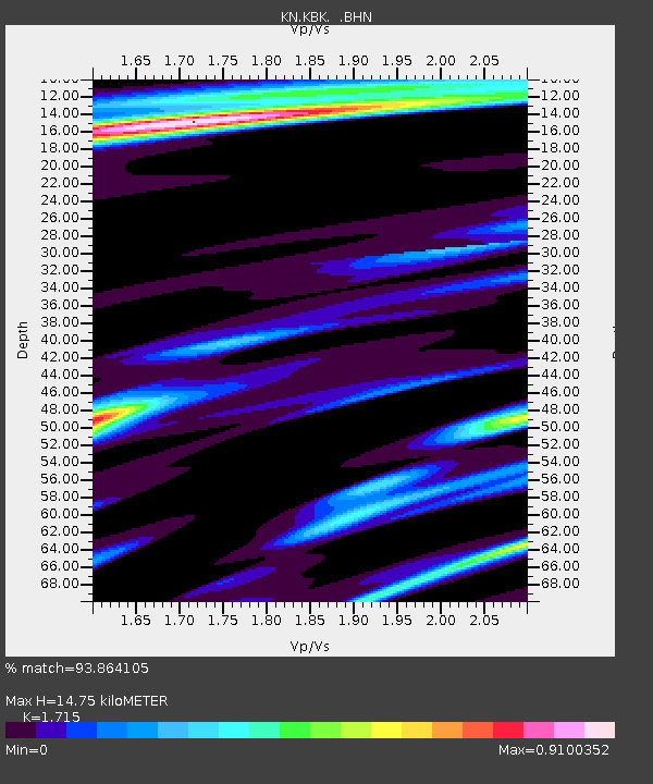
KBK KN.KBK - Earthquake Result Viewer
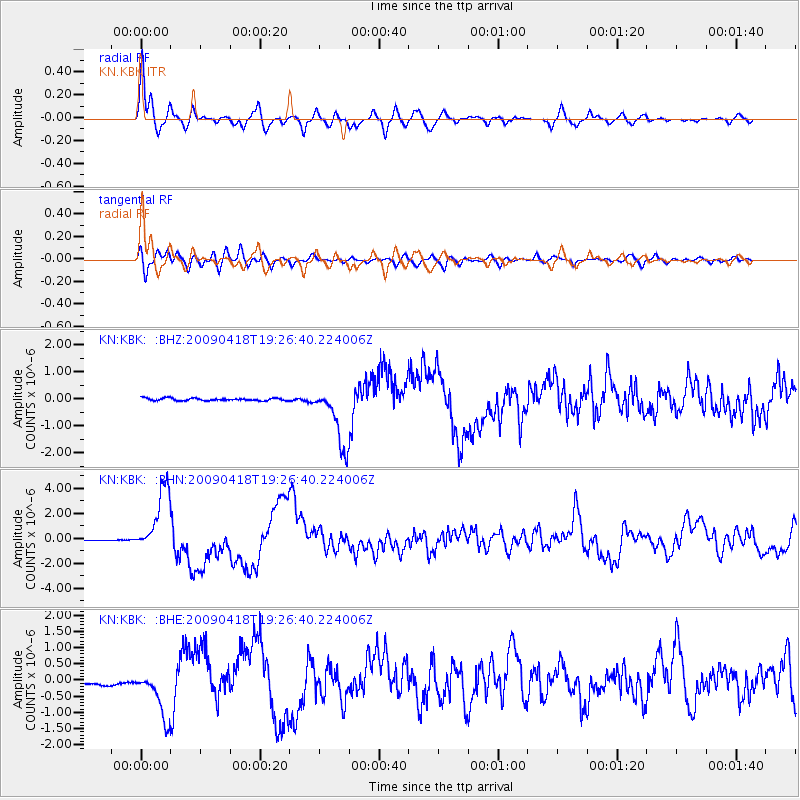
Earthquake location: Kuril Islands
Earthquake latitude/longitude: 46.0/151.4
Earthquake time(UTC): 2009/04/18 (108) 19:17:58 GMT
Earthquake Depth: 35 km
Earthquake Magnitude: 6.3 MB, 6.3 MS, 6.6 MW, 6.4 MW
Earthquake Catalog/Contributor: WHDF/NEIC
Network: KN Kyrgyz Seismic Telemetry Network
Station: KBK KN.KBK
Lat/Lon: 42.66 N/74.95 E
Elevation: 1760 m
Distance: 52.8 deg
Az: 295.804 deg
Baz: 58.264 deg
Ray Param: 0.06644869
Estimated Moho Depth: 14.75 km
Estimated Crust Vp/Vs: 1.72
Assumed Crust Vp: 6.306 km/s
Estimated Crust Vs: 3.677 km/s
Estimated Crust Poisson's Ratio: 0.24
Radial Match: 93.864105 %
Radial Bump: 400
Transverse Match: 81.05908 %
Transverse Bump: 400
SOD ConfigId: 2760
Insert Time: 2010-03-08 20:09:57.724 +0000
GWidth: 2.5
Max Bumps: 400
Tol: 0.001

Signal To Noise

ChannelStoNSTALTA
KN:KBK: :BHN:20090418T19:26:40.224006Z52.116872.5837599E-64.957626E-8
KN:KBK: :BHE:20090418T19:26:40.224006Z8.7994427.376472E-78.382886E-8
KN:KBK: :BHZ:20090418T19:26:40.224006Z24.8470461.1348887E-64.5674998E-8
Arrivals
Ps1.8 SECOND
PpPs6.0 SECOND
PsPs/PpSs7.8 SECOND