You are here: Home > Network List > GS - US Geological Survey Networks Stations List
> Station KAN08 Pence Farm, Harper, KS, USA > Earthquake Result Viewer
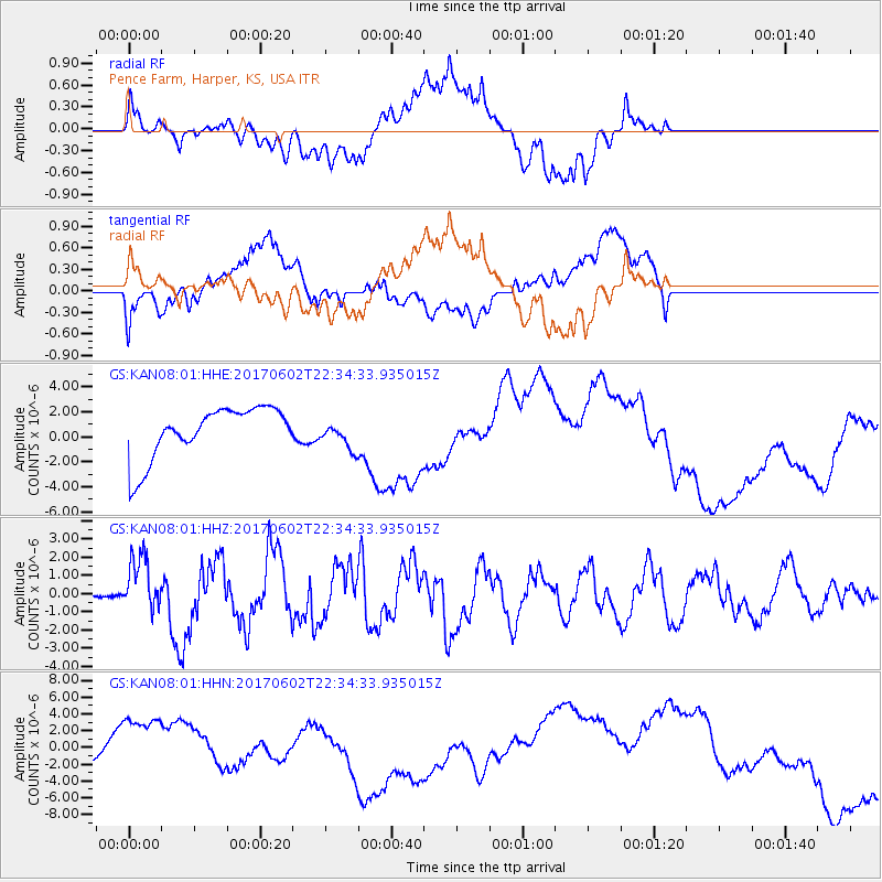
KAN08 Pence Farm, Harper, KS, USA - Earthquake Result Viewer
*The percent match for this event was below the threshold and hence no stack was calculated.
| Earthquake location: |
Near Islands, Aleutian Islands |
| Earthquake latitude/longitude: |
54.0/170.9 |
| Earthquake time(UTC): |
2017/06/02 (153) 22:24:47 GMT |
| Earthquake Depth: |
8.2 km |
| Earthquake Magnitude: |
6.8 Mww |
| Earthquake Catalog/Contributor: |
NEIC PDE/us |
|
| Network: |
GS US Geological Survey Networks |
| Station: |
KAN08 Pence Farm, Harper, KS, USA |
| Lat/Lon: |
37.23 N/97.97 W |
| Elevation: |
375 m |
|
| Distance: |
61.5 deg |
| Az: |
65.246 deg |
| Baz: |
317.841 deg |
| Ray Param: |
$rayparam |
*The percent match for this event was below the threshold and hence was not used in the summary stack. |
|
| Radial Match: |
17.310417 % |
| Radial Bump: |
400 |
| Transverse Match: |
60.496525 % |
| Transverse Bump: |
400 |
| SOD ConfigId: |
2140511 |
| Insert Time: |
2017-06-16 14:20:58.067 +0000 |
| GWidth: |
2.5 |
| Max Bumps: |
400 |
| Tol: |
0.001 |
|
Signal To Noise
| Channel | StoN | STA | LTA |
| GS:KAN08:01:HHZ:20170602T22:34:33.935015Z | 15.3694 | 1.5383708E-6 | 1.0009309E-7 |
| GS:KAN08:01:HHN:20170602T22:34:33.935015Z | 1.1895754 | 3.8907274E-6 | 3.2706857E-6 |
| GS:KAN08:01:HHE:20170602T22:34:33.935015Z | 0.5093889 | 1.0510751E-6 | 2.0634038E-6 |
| Arrivals |
| Ps | |
| PpPs | |
| PsPs/PpSs | |


