You are here: Home > Network List > TS - TERRAscope (Southern California Seismic Network) Stations List
> Station SMTC Superstition Mountain, California, USA > Earthquake Result Viewer
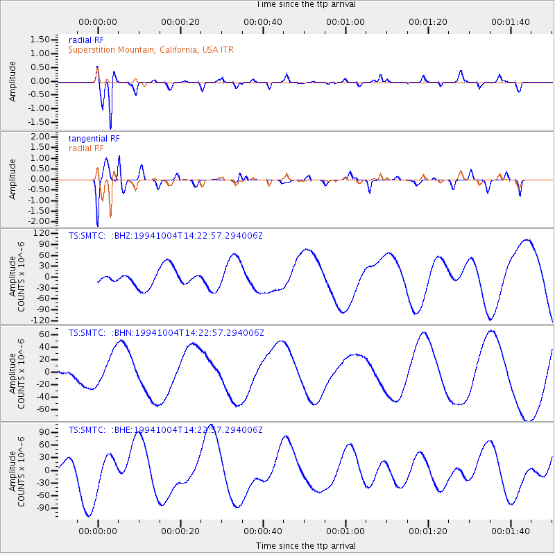
SMTC Superstition Mountain, California, USA - Earthquake Result Viewer
*The percent match for this event was below the threshold and hence no stack was calculated.
| Earthquake location: |
Kuril Islands |
| Earthquake latitude/longitude: |
43.9/147.1 |
| Earthquake time(UTC): |
1994/10/04 (277) 14:12:04 GMT |
| Earthquake Depth: |
33 km |
| Earthquake Magnitude: |
5.5 MB |
| Earthquake Catalog/Contributor: |
WHDF/NEIC |
|
| Network: |
TS TERRAscope (Southern California Seismic Network) |
| Station: |
SMTC Superstition Mountain, California, USA |
| Lat/Lon: |
32.95 N/115.72 W |
| Elevation: |
-50.0 m |
|
| Distance: |
72.6 deg |
| Az: |
60.936 deg |
| Baz: |
311.296 deg |
| Ray Param: |
$rayparam |
*The percent match for this event was below the threshold and hence was not used in the summary stack. |
|
| Radial Match: |
81.00729 % |
| Radial Bump: |
400 |
| Transverse Match: |
67.88899 % |
| Transverse Bump: |
400 |
| SOD ConfigId: |
4480 |
| Insert Time: |
2010-02-26 14:50:29.019 +0000 |
| GWidth: |
2.5 |
| Max Bumps: |
400 |
| Tol: |
0.001 |
|
Signal To Noise
| Channel | StoN | STA | LTA |
| TS:SMTC: :BHN:19941004T14:22:57.294006Z | 3.4906285 | 2.6288839E-5 | 7.5312623E-6 |
| TS:SMTC: :BHE:19941004T14:22:57.294006Z | 1.0447915 | 3.886985E-5 | 3.7203452E-5 |
| TS:SMTC: :BHZ:19941004T14:22:57.294006Z | 2.0425403 | 4.654575E-5 | 2.2788166E-5 |
| Arrivals |
| Ps | |
| PpPs | |
| PsPs/PpSs | |


