KBK KN.KBK - Earthquake Result Viewer
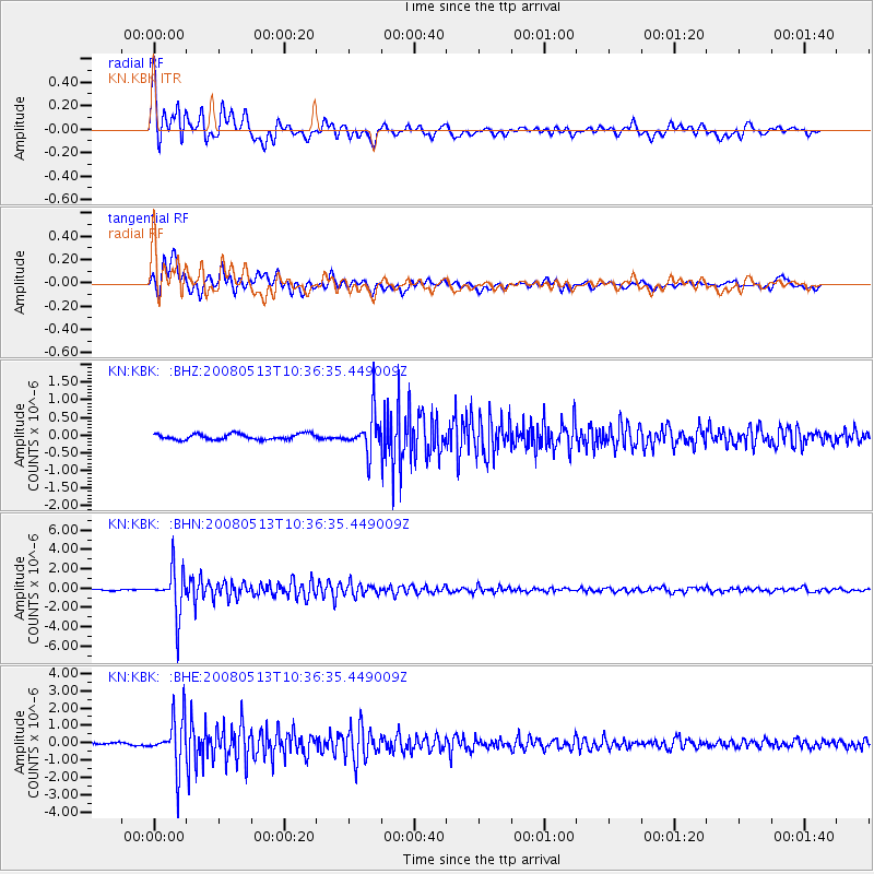
Earthquake location: Northern Sumatra, Indonesia
Earthquake latitude/longitude: 4.7/95.1
Earthquake time(UTC): 2008/05/13 (134) 10:29:19 GMT
Earthquake Depth: 35 km
Earthquake Magnitude: 5.6 MB, 5.1 MS, 5.4 MW, 5.4 MW
Earthquake Catalog/Contributor: WHDF/NEIC
Network: KN Kyrgyz Seismic Telemetry Network
Station: KBK KN.KBK
Lat/Lon: 42.66 N/74.95 E
Elevation: 1760 m
Distance: 41.8 deg
Az: 337.618 deg
Baz: 149.037 deg
Ray Param: 0.07346042
Estimated Moho Depth: 67.75 km
Estimated Crust Vp/Vs: 1.64
Assumed Crust Vp: 6.306 km/s
Estimated Crust Vs: 3.845 km/s
Estimated Crust Poisson's Ratio: 0.20
Radial Match: 94.25082 %
Radial Bump: 400
Transverse Match: 87.75275 %
Transverse Bump: 400
SOD ConfigId: 2504
Insert Time: 2010-03-08 20:10:22.368 +0000
GWidth: 2.5
Max Bumps: 400
Tol: 0.001

Signal To Noise

ChannelStoNSTALTA
KN:KBK: :BHN:20080513T10:36:35.449009Z29.436742.2943868E-67.7942964E-8
KN:KBK: :BHE:20080513T10:36:35.449009Z18.1692351.4177036E-67.8027696E-8
KN:KBK: :BHZ:20080513T10:36:35.449009Z6.77457865.4372265E-78.025926E-8
Arrivals
Ps7.4 SECOND
PpPs26 SECOND
PsPs/PpSs34 SECOND