You are here: Home > Network List > KN - Kyrgyz Seismic Telemetry Network Stations List
> Station KBK KN.KBK > Earthquake Result Viewer
KBK KN.KBK - Earthquake Result Viewer
| Earthquake location: |
Mid-Indian Ridge |
| Earthquake latitude/longitude: |
-41.2/80.5 |
| Earthquake time(UTC): |
2008/05/31 (152) 04:37:56 GMT |
| Earthquake Depth: |
10 km |
| Earthquake Magnitude: |
6.0 MB, 6.3 MS, 6.4 MW, 6.4 MW |
| Earthquake Catalog/Contributor: |
WHDF/NEIC |
|
| Network: |
KN Kyrgyz Seismic Telemetry Network |
| Station: |
KBK KN.KBK |
| Lat/Lon: |
42.66 N/74.95 E |
| Elevation: |
1760 m |
|
| Distance: |
83.6 deg |
| Az: |
355.875 deg |
| Baz: |
175.781 deg |
| Ray Param: |
0.046044353 |
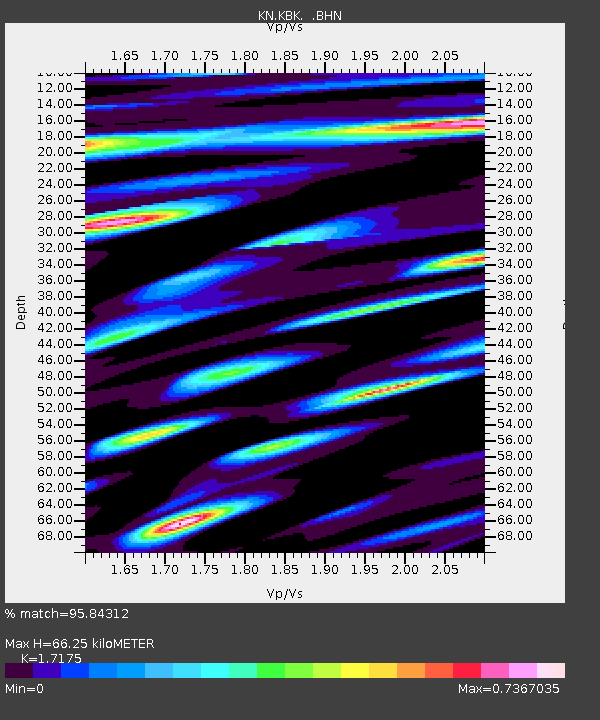
| Estimated Moho Depth: |
66.25 km |
| Estimated Crust Vp/Vs: |
1.72 |
| Assumed Crust Vp: |
6.306 km/s |
| Estimated Crust Vs: |
3.672 km/s |
| Estimated Crust Poisson's Ratio: |
0.24 |
|
| Radial Match: |
95.84312 % |
| Radial Bump: |
397 |
| Transverse Match: |
89.460335 % |
| Transverse Bump: |
400 |
| SOD ConfigId: |
2504 |
| Insert Time: |
2010-03-08 20:10:31.315 +0000 |
| GWidth: |
2.5 |
| Max Bumps: |
400 |
| Tol: |
0.001 |
|

Signal To Noise
| Channel | StoN | STA | LTA |
| KN:KBK: :BHN:20080531T04:49:53.350005Z | 12.163999 | 6.4573754E-7 | 5.3085962E-8 |
| KN:KBK: :BHE:20080531T04:49:53.350005Z | 5.0510464 | 2.5050454E-7 | 4.9594583E-8 |
| KN:KBK: :BHZ:20080531T04:49:53.350005Z | 0.7545363 | 9.9122424E-8 | 1.3136867E-7 |
| Arrivals |
| Ps | 7.7 SECOND |
| PpPs | 28 SECOND |
| PsPs/PpSs | 36 SECOND |


