You are here: Home > Network List > TA - USArray Transportable Network (new EarthScope stations) Stations List
> Station D17K Noatak River, AK, USA > Earthquake Result Viewer
D17K Noatak River, AK, USA - Earthquake Result Viewer
| Earthquake location: |
Vanuatu Islands |
| Earthquake latitude/longitude: |
-16.1/168.0 |
| Earthquake time(UTC): |
2020/05/16 (137) 03:15:43 GMT |
| Earthquake Depth: |
166 km |
| Earthquake Magnitude: |
5.9 mww |
| Earthquake Catalog/Contributor: |
NEIC PDE/us |
|
| Network: |
TA USArray Transportable Network (new EarthScope stations) |
| Station: |
D17K Noatak River, AK, USA |
| Lat/Lon: |
67.70 N/163.08 W |
| Elevation: |
172 m |
|
| Distance: |
86.2 deg |
| Az: |
10.665 deg |
| Baz: |
207.784 deg |
| Ray Param: |
0.04385383 |
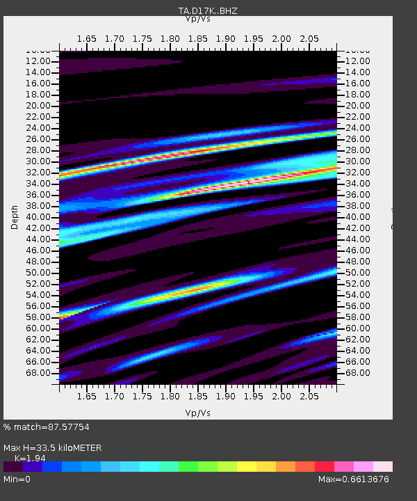
| Estimated Moho Depth: |
33.5 km |
| Estimated Crust Vp/Vs: |
1.94 |
| Assumed Crust Vp: |
6.276 km/s |
| Estimated Crust Vs: |
3.235 km/s |
| Estimated Crust Poisson's Ratio: |
0.32 |
|
| Radial Match: |
87.57754 % |
| Radial Bump: |
286 |
| Transverse Match: |
71.24685 % |
| Transverse Bump: |
380 |
| SOD ConfigId: |
21166931 |
| Insert Time: |
2020-05-30 03:26:36.260 +0000 |
| GWidth: |
2.5 |
| Max Bumps: |
400 |
| Tol: |
0.001 |
|

Signal To Noise
| Channel | StoN | STA | LTA |
| TA:D17K: :BHZ:20200516T03:27:34.825024Z | 8.1610985 | 3.701502E-7 | 4.5355435E-8 |
| TA:D17K: :BHN:20200516T03:27:34.825024Z | 3.0935194 | 1.6673506E-7 | 5.3898177E-8 |
| TA:D17K: :BHE:20200516T03:27:34.825024Z | 0.80516505 | 5.3700997E-8 | 6.669564E-8 |
| Arrivals |
| Ps | 5.1 SECOND |
| PpPs | 15 SECOND |
| PsPs/PpSs | 21 SECOND |


