You are here: Home > Network List > KN - Kyrgyz Seismic Telemetry Network Stations List
> Station KBK KN.KBK > Earthquake Result Viewer
KBK KN.KBK - Earthquake Result Viewer
| Earthquake location: |
Sea Of Okhotsk |
| Earthquake latitude/longitude: |
53.9/152.9 |
| Earthquake time(UTC): |
2008/07/05 (187) 02:12:04 GMT |
| Earthquake Depth: |
633 km |
| Earthquake Magnitude: |
6.8 MB, 7.7 MW, 7.7 MW |
| Earthquake Catalog/Contributor: |
WHDF/NEIC |
|
| Network: |
KN Kyrgyz Seismic Telemetry Network |
| Station: |
KBK KN.KBK |
| Lat/Lon: |
42.66 N/74.95 E |
| Elevation: |
1760 m |
|
| Distance: |
50.6 deg |
| Az: |
290.899 deg |
| Baz: |
48.568 deg |
| Ray Param: |
0.06498251 |
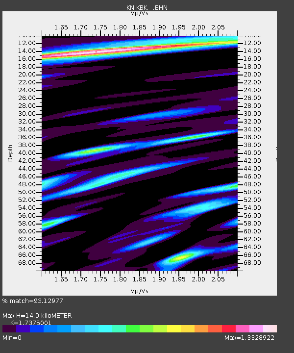
| Estimated Moho Depth: |
14.0 km |
| Estimated Crust Vp/Vs: |
1.74 |
| Assumed Crust Vp: |
6.306 km/s |
| Estimated Crust Vs: |
3.629 km/s |
| Estimated Crust Poisson's Ratio: |
0.25 |
|
| Radial Match: |
93.12977 % |
| Radial Bump: |
400 |
| Transverse Match: |
92.49651 % |
| Transverse Bump: |
400 |
| SOD ConfigId: |
2504 |
| Insert Time: |
2010-03-08 20:10:43.640 +0000 |
| GWidth: |
2.5 |
| Max Bumps: |
400 |
| Tol: |
0.001 |
|
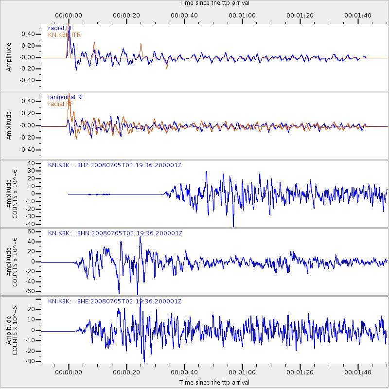
Signal To Noise
| Channel | StoN | STA | LTA |
| KN:KBK: :BHN:20080705T02:19:36.200001Z | 14.095755 | 3.2603455E-6 | 2.3129982E-7 |
| KN:KBK: :BHE:20080705T02:19:36.200001Z | 8.728511 | 8.599698E-7 | 9.8524225E-8 |
| KN:KBK: :BHZ:20080705T02:19:36.200001Z | 8.845676 | 9.4405453E-7 | 1.0672497E-7 |
| Arrivals |
| Ps | 1.7 SECOND |
| PpPs | 5.8 SECOND |
| PsPs/PpSs | 7.5 SECOND |


