You are here: Home > Network List > KN - Kyrgyz Seismic Telemetry Network Stations List
> Station KBK KN.KBK > Earthquake Result Viewer
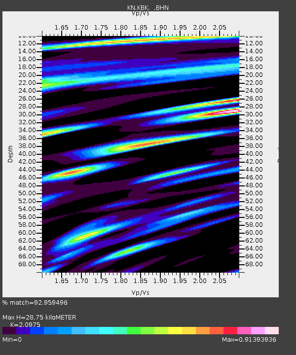
KBK KN.KBK - Earthquake Result Viewer
| Earthquake location: |
Halmahera, Indonesia |
| Earthquake latitude/longitude: |
1.9/127.4 |
| Earthquake time(UTC): |
2008/09/11 (255) 00:00:02 GMT |
| Earthquake Depth: |
96 km |
| Earthquake Magnitude: |
6.2 MB, 6.6 MW, 6.6 MW |
| Earthquake Catalog/Contributor: |
WHDF/NEIC |
|
| Network: |
KN Kyrgyz Seismic Telemetry Network |
| Station: |
KBK KN.KBK |
| Lat/Lon: |
42.66 N/74.95 E |
| Elevation: |
1760 m |
|
| Distance: |
61.9 deg |
| Az: |
318.471 deg |
| Baz: |
116.068 deg |
| Ray Param: |
0.06034743 |
| Estimated Moho Depth: |
28.75 km |
| Estimated Crust Vp/Vs: |
2.10 |
| Assumed Crust Vp: |
6.306 km/s |
| Estimated Crust Vs: |
3.006 km/s |
| Estimated Crust Poisson's Ratio: |
0.35 |
|
| Radial Match: |
92.959496 % |
| Radial Bump: |
400 |
| Transverse Match: |
90.76398 % |
| Transverse Bump: |
400 |
| SOD ConfigId: |
2560 |
| Insert Time: |
2010-03-08 20:11:12.892 +0000 |
| GWidth: |
2.5 |
| Max Bumps: |
400 |
| Tol: |
0.001 |
|

Signal To Noise
| Channel | StoN | STA | LTA |
| KN:KBK: :BHN:20080911T00:09:41.025012Z | 32.44809 | 2.4692597E-6 | 7.609877E-8 |
| KN:KBK: :BHE:20080911T00:09:41.025012Z | 5.573444 | 3.5505198E-7 | 6.3704235E-8 |
| KN:KBK: :BHZ:20080911T00:09:41.025012Z | 28.470415 | 1.0057187E-6 | 3.5325044E-8 |
| Arrivals |
| Ps | 5.2 SECOND |
| PpPs | 14 SECOND |
| PsPs/PpSs | 19 SECOND |


