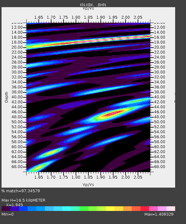
KBK KN.KBK - Earthquake Result Viewer

Earthquake location: Southern Sumatra, Indonesia
Earthquake latitude/longitude: -2.2/99.8
Earthquake time(UTC): 2008/02/25 (056) 21:02:18 GMT
Earthquake Depth: 25 km
Earthquake Magnitude: 6.2 MB, 6.6 MS, 6.6 MW, 6.5 MW
Earthquake Catalog/Contributor: WHDF/NEIC
Network: KN Kyrgyz Seismic Telemetry Network
Station: KBK KN.KBK
Lat/Lon: 42.66 N/74.95 E
Elevation: 1760 m
Distance: 50.0 deg
Az: 336.125 deg
Baz: 146.753 deg
Ray Param: 0.0682932
Estimated Moho Depth: 16.5 km
Estimated Crust Vp/Vs: 1.95
Assumed Crust Vp: 6.306 km/s
Estimated Crust Vs: 3.242 km/s
Estimated Crust Poisson's Ratio: 0.32
Radial Match: 97.34579 %
Radial Bump: 373
Transverse Match: 95.261314 %
Transverse Bump: 400
SOD ConfigId: 2564
Insert Time: 2010-03-08 20:11:36.160 +0000
GWidth: 2.5
Max Bumps: 400
Tol: 0.001

Signal To Noise

ChannelStoNSTALTA
KN:KBK: :BHN:20080225T21:10:39.848009Z14.0750961.9147133E-61.3603554E-7
KN:KBK: :BHE:20080225T21:10:39.848009Z8.3800861.6377585E-61.9543457E-7
KN:KBK: :BHZ:20080225T21:10:39.848009Z55.572685.3542794E-69.6347335E-8
Arrivals
Ps2.6 SECOND
PpPs7.3 SECOND
PsPs/PpSs9.9 SECOND