You are here: Home > Network List > RM - Regional Integrated Multi Hazard Early Warning System Stations List
> Station SZP Santa Ilocos Sur > Earthquake Result Viewer
SZP Santa Ilocos Sur - Earthquake Result Viewer
| Earthquake location: |
Off Coast Of Northern California |
| Earthquake latitude/longitude: |
40.8/-127.6 |
| Earthquake time(UTC): |
2020/05/18 (139) 07:02:32 GMT |
| Earthquake Depth: |
11 km |
| Earthquake Magnitude: |
5.5 Mi |
| Earthquake Catalog/Contributor: |
NEIC PDE/at |
|
| Network: |
RM Regional Integrated Multi Hazard Early Warning System |
| Station: |
SZP Santa Ilocos Sur |
| Lat/Lon: |
17.55 N/120.46 E |
| Elevation: |
100 m |
|
| Distance: |
94.3 deg |
| Az: |
297.446 deg |
| Baz: |
44.924 deg |
| Ray Param: |
0.041068897 |
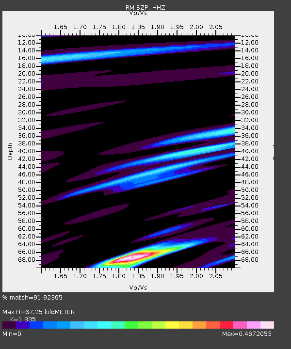
| Estimated Moho Depth: |
67.25 km |
| Estimated Crust Vp/Vs: |
1.84 |
| Assumed Crust Vp: |
6.468 km/s |
| Estimated Crust Vs: |
3.525 km/s |
| Estimated Crust Poisson's Ratio: |
0.29 |
|
| Radial Match: |
91.92365 % |
| Radial Bump: |
235 |
| Transverse Match: |
62.679306 % |
| Transverse Bump: |
400 |
| SOD ConfigId: |
21166931 |
| Insert Time: |
2020-06-01 07:10:33.025 +0000 |
| GWidth: |
2.5 |
| Max Bumps: |
400 |
| Tol: |
0.001 |
|

Signal To Noise
| Channel | StoN | STA | LTA |
| RM:SZP: :HHZ:20200518T07:15:19.788025Z | 0.8915951 | 3.0135217E-7 | 3.3799216E-7 |
| RM:SZP: :HHN:20200518T07:15:19.788025Z | 1.3547261 | 3.7511882E-7 | 2.7689643E-7 |
| RM:SZP: :HHE:20200518T07:15:19.788025Z | 1.3952643 | 4.2763867E-7 | 3.0649295E-7 |
| Arrivals |
| Ps | 8.9 SECOND |
| PpPs | 29 SECOND |
| PsPs/PpSs | 38 SECOND |


