You are here: Home > Network List > TA - USArray Transportable Network (new EarthScope stations) Stations List
> Station A22K Sinclair Lake, AK, USA > Earthquake Result Viewer
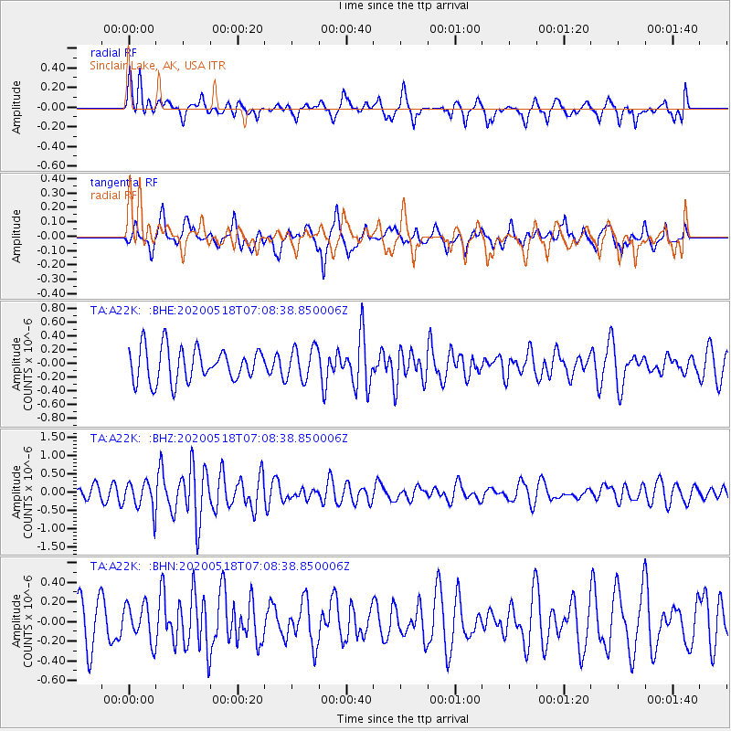
A22K Sinclair Lake, AK, USA - Earthquake Result Viewer
*The percent match for this event was below the threshold and hence no stack was calculated.
| Earthquake location: |
Off Coast Of Northern California |
| Earthquake latitude/longitude: |
40.8/-127.6 |
| Earthquake time(UTC): |
2020/05/18 (139) 07:02:32 GMT |
| Earthquake Depth: |
11 km |
| Earthquake Magnitude: |
5.5 Mi |
| Earthquake Catalog/Contributor: |
NEIC PDE/at |
|
| Network: |
TA USArray Transportable Network (new EarthScope stations) |
| Station: |
A22K Sinclair Lake, AK, USA |
| Lat/Lon: |
71.00 N/154.97 W |
| Elevation: |
6.0 m |
|
| Distance: |
33.3 deg |
| Az: |
344.084 deg |
| Baz: |
140.527 deg |
| Ray Param: |
$rayparam |
*The percent match for this event was below the threshold and hence was not used in the summary stack. |
|
| Radial Match: |
54.353073 % |
| Radial Bump: |
400 |
| Transverse Match: |
57.466763 % |
| Transverse Bump: |
400 |
| SOD ConfigId: |
21166931 |
| Insert Time: |
2020-06-01 07:11:05.008 +0000 |
| GWidth: |
2.5 |
| Max Bumps: |
400 |
| Tol: |
0.001 |
|
Signal To Noise
| Channel | StoN | STA | LTA |
| TA:A22K: :BHZ:20200518T07:08:38.850006Z | 2.4485648 | 3.914449E-7 | 1.5986708E-7 |
| TA:A22K: :BHN:20200518T07:08:38.850006Z | 0.6547093 | 1.874265E-7 | 2.8627437E-7 |
| TA:A22K: :BHE:20200518T07:08:38.850006Z | 0.96739477 | 2.3408084E-7 | 2.4197035E-7 |
| Arrivals |
| Ps | |
| PpPs | |
| PsPs/PpSs | |


