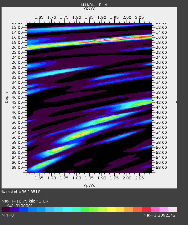
KBK KN.KBK - Earthquake Result Viewer

Earthquake location: Off W Coast Of Northern Sumatra
Earthquake latitude/longitude: 2.8/96.0
Earthquake time(UTC): 2008/02/20 (051) 08:08:30 GMT
Earthquake Depth: 26 km
Earthquake Magnitude: 6.5 MB, 7.5 MS, 7.4 MW, 7.4 MW
Earthquake Catalog/Contributor: WHDF/NEIC
Network: KN Kyrgyz Seismic Telemetry Network
Station: KBK KN.KBK
Lat/Lon: 42.66 N/74.95 E
Elevation: 1760 m
Distance: 43.9 deg
Az: 337.583 deg
Baz: 148.912 deg
Ray Param: 0.07218715
Estimated Moho Depth: 16.75 km
Estimated Crust Vp/Vs: 1.91
Assumed Crust Vp: 6.306 km/s
Estimated Crust Vs: 3.302 km/s
Estimated Crust Poisson's Ratio: 0.31
Radial Match: 96.18518 %
Radial Bump: 400
Transverse Match: 93.65358 %
Transverse Bump: 400
SOD ConfigId: 2564
Insert Time: 2010-03-08 20:11:45.346 +0000
GWidth: 2.5
Max Bumps: 400
Tol: 0.001

Signal To Noise

ChannelStoNSTALTA
KN:KBK: :BHN:20080220T08:16:04.375011Z15.6829551.6226321E-61.0346469E-7
KN:KBK: :BHE:20080220T08:16:04.375011Z13.2431721.3316704E-61.00555255E-7
KN:KBK: :BHZ:20080220T08:16:04.375011Z25.4513854.3631953E-61.7143252E-7
Arrivals
Ps2.6 SECOND
PpPs7.3 SECOND
PsPs/PpSs9.9 SECOND