You are here: Home > Network List > KN - Kyrgyz Seismic Telemetry Network Stations List
> Station KBK KN.KBK > Earthquake Result Viewer
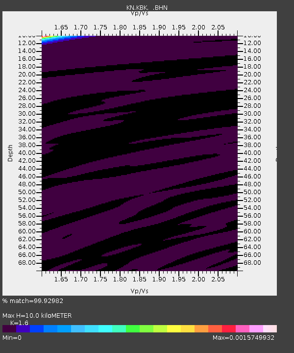
KBK KN.KBK - Earthquake Result Viewer
| Earthquake location: |
Southwest Indian Ridge |
| Earthquake latitude/longitude: |
-35.4/53.9 |
| Earthquake time(UTC): |
2008/01/14 (014) 01:20:02 GMT |
| Earthquake Depth: |
10 km |
| Earthquake Magnitude: |
5.5 MB, 5.0 MS |
| Earthquake Catalog/Contributor: |
WHDF/NEIC |
|
| Network: |
KN Kyrgyz Seismic Telemetry Network |
| Station: |
KBK KN.KBK |
| Lat/Lon: |
42.66 N/74.95 E |
| Elevation: |
1760 m |
|
| Distance: |
80.0 deg |
| Az: |
15.621 deg |
| Baz: |
197.349 deg |
| Ray Param: |
0.04855114 |
| Estimated Moho Depth: |
10.0 km |
| Estimated Crust Vp/Vs: |
1.60 |
| Assumed Crust Vp: |
6.306 km/s |
| Estimated Crust Vs: |
3.941 km/s |
| Estimated Crust Poisson's Ratio: |
0.18 |
|
| Radial Match: |
99.92982 % |
| Radial Bump: |
7 |
| Transverse Match: |
99.35741 % |
| Transverse Bump: |
102 |
| SOD ConfigId: |
2564 |
| Insert Time: |
2010-03-08 20:11:49.673 +0000 |
| GWidth: |
2.5 |
| Max Bumps: |
400 |
| Tol: |
0.001 |
|

Signal To Noise
| Channel | StoN | STA | LTA |
| KN:KBK: :BHN:20080114T01:31:40.900022Z | 0.92154217 | 3.1568499E-7 | 3.425616E-7 |
| KN:KBK: :BHE:20080114T01:31:40.900022Z | 1.5419474 | 5.6025726E-7 | 3.6334396E-7 |
| KN:KBK: :BHZ:20080114T01:31:40.900022Z | 0.874017 | 4.0235855E-7 | 4.6035552E-7 |
| Arrivals |
| Ps | 1.0 SECOND |
| PpPs | 4.0 SECOND |
| PsPs/PpSs | 5.0 SECOND |


