You are here: Home > Network List > KN - Kyrgyz Seismic Telemetry Network Stations List
> Station KBK KN.KBK > Earthquake Result Viewer
KBK KN.KBK - Earthquake Result Viewer
| Earthquake location: |
Halmahera, Indonesia |
| Earthquake latitude/longitude: |
1.0/127.7 |
| Earthquake time(UTC): |
1994/01/21 (021) 02:24:31 GMT |
| Earthquake Depth: |
33 km |
| Earthquake Magnitude: |
7.2 MS, 7.0 UNKNOWN |
| Earthquake Catalog/Contributor: |
WHDF/NEIC |
|
| Network: |
KN Kyrgyz Seismic Telemetry Network |
| Station: |
KBK KN.KBK |
| Lat/Lon: |
42.66 N/74.95 E |
| Elevation: |
1760 m |
|
| Distance: |
62.7 deg |
| Az: |
318.637 deg |
| Baz: |
116.405 deg |
| Ray Param: |
0.05997191 |
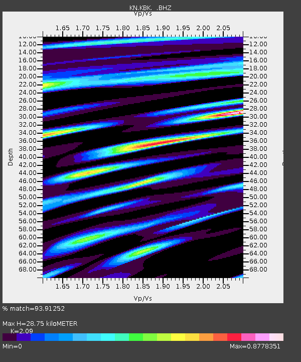
| Estimated Moho Depth: |
28.75 km |
| Estimated Crust Vp/Vs: |
2.09 |
| Assumed Crust Vp: |
6.306 km/s |
| Estimated Crust Vs: |
3.017 km/s |
| Estimated Crust Poisson's Ratio: |
0.35 |
|
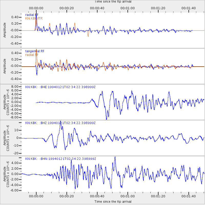
| Radial Match: |
93.91252 % |
| Radial Bump: |
400 |
| Transverse Match: |
90.05942 % |
| Transverse Bump: |
400 |
| SOD ConfigId: |
4480 |
| Insert Time: |
2010-03-08 20:12:09.425 +0000 |
| GWidth: |
2.5 |
| Max Bumps: |
400 |
| Tol: |
0.001 |
|
Signal To Noise
| Channel | StoN | STA | LTA |
| KN:KBK: :BHZ:19940121T02:34:22.398999Z | 2.7369938 | 2.261152E-7 | 8.2614434E-8 |
| KN:KBK: :BHN:19940121T02:34:22.398999Z | 1.6336561 | 2.3708924E-7 | 1.45128E-7 |
| KN:KBK: :BHE:19940121T02:34:22.398999Z | 1.4086574 | 1.7386876E-7 | 1.2342869E-7 |
| Arrivals |
| Ps | 5.2 SECOND |
| PpPs | 14 SECOND |
| PsPs/PpSs | 19 SECOND |


