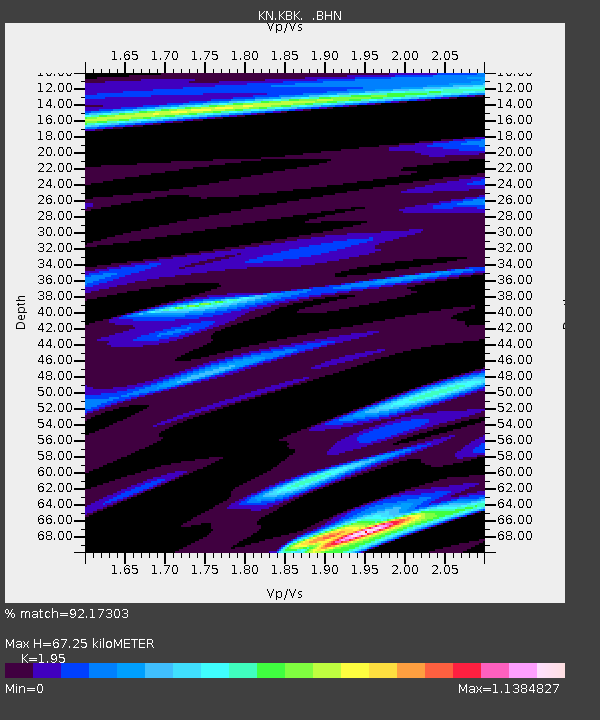
KBK KN.KBK - Earthquake Result Viewer
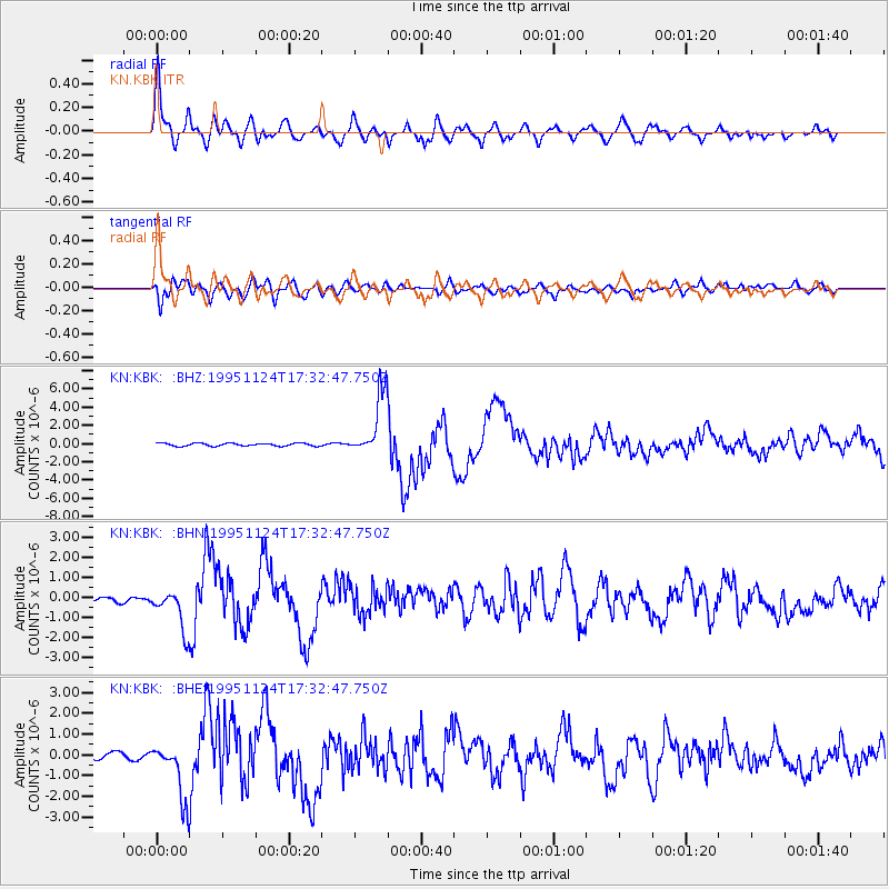
Earthquake location: Kuril Islands
Earthquake latitude/longitude: 44.5/149.1
Earthquake time(UTC): 1995/11/24 (328) 17:24:12 GMT
Earthquake Depth: 33 km
Earthquake Magnitude: 6.1 MB, 6.3 MS, 6.1 UNKNOWN, 6.6 MW
Earthquake Catalog/Contributor: WHDF/NEIC
Network: KN Kyrgyz Seismic Telemetry Network
Station: KBK KN.KBK
Lat/Lon: 42.66 N/74.95 E
Elevation: 1760 m
Distance: 52.0 deg
Az: 295.724 deg
Baz: 60.843 deg
Ray Param: 0.066999756
Estimated Moho Depth: 67.25 km
Estimated Crust Vp/Vs: 1.95
Assumed Crust Vp: 6.306 km/s
Estimated Crust Vs: 3.234 km/s
Estimated Crust Poisson's Ratio: 0.32
Radial Match: 92.17303 %
Radial Bump: 400
Transverse Match: 85.2284 %
Transverse Bump: 400
SOD ConfigId: 6273
Insert Time: 2010-03-08 20:12:14.671 +0000
GWidth: 2.5
Max Bumps: 400
Tol: 0.001

Signal To Noise

ChannelStoNSTALTA
KN:KBK: :BHN:19951124T17:32:47.750Z8.3087141.0142486E-61.2207046E-7
KN:KBK: :BHE:19951124T17:32:47.750Z6.7648131.3227316E-61.9553114E-7
KN:KBK: :BHZ:19951124T17:32:47.750Z22.038763.4347445E-61.5585017E-7
Arrivals
Ps11 SECOND
PpPs30 SECOND
PsPs/PpSs41 SECOND