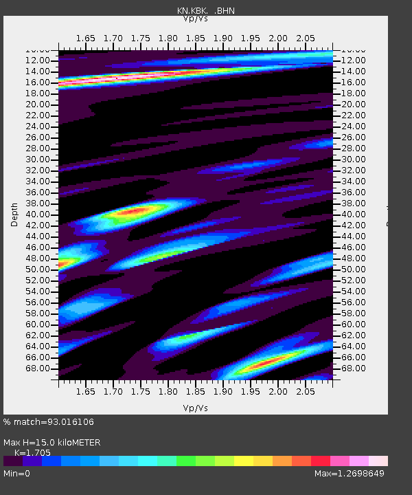
KBK KN.KBK - Earthquake Result Viewer
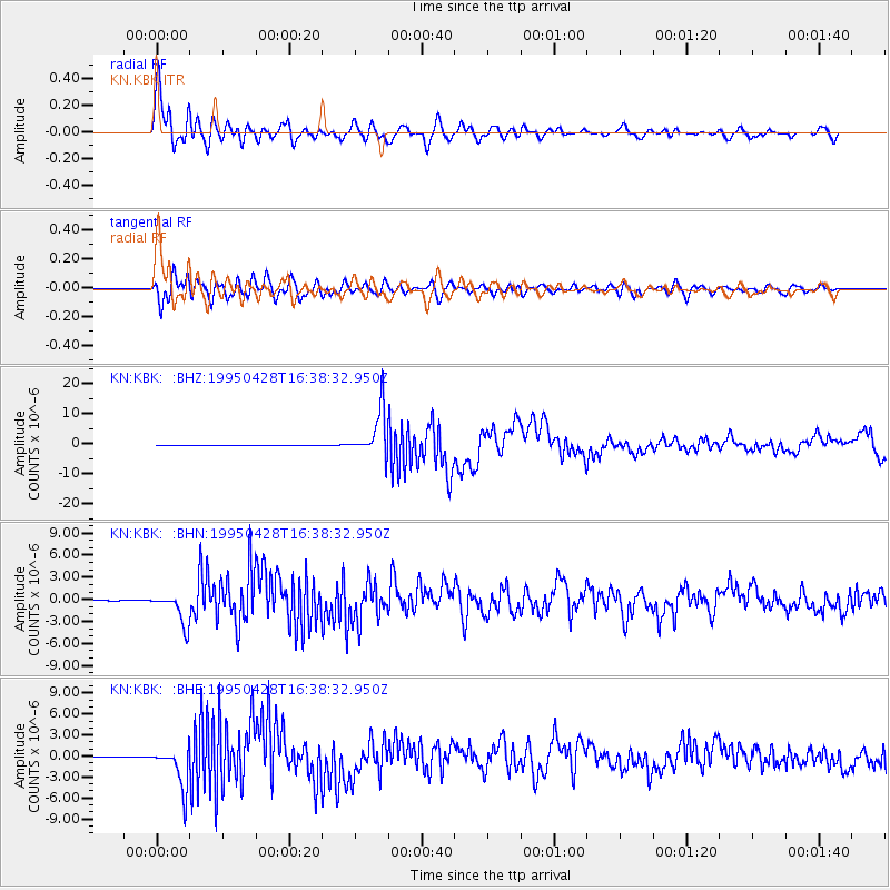
Earthquake location: Kuril Islands
Earthquake latitude/longitude: 44.1/148.1
Earthquake time(UTC): 1995/04/28 (118) 16:30:00 GMT
Earthquake Depth: 29 km
Earthquake Magnitude: 6.6 MB, 6.9 MS, 7.0 UNKNOWN, 6.8 MW
Earthquake Catalog/Contributor: WHDF/NEIC
Network: KN Kyrgyz Seismic Telemetry Network
Station: KBK KN.KBK
Lat/Lon: 42.66 N/74.95 E
Elevation: 1760 m
Distance: 51.5 deg
Az: 295.601 deg
Baz: 61.809 deg
Ray Param: 0.067317665
Estimated Moho Depth: 15.0 km
Estimated Crust Vp/Vs: 1.71
Assumed Crust Vp: 6.306 km/s
Estimated Crust Vs: 3.699 km/s
Estimated Crust Poisson's Ratio: 0.24
Radial Match: 93.016106 %
Radial Bump: 400
Transverse Match: 88.985664 %
Transverse Bump: 400
SOD ConfigId: 6273
Insert Time: 2010-03-08 20:12:22.249 +0000
GWidth: 2.5
Max Bumps: 400
Tol: 0.001

Signal To Noise

ChannelStoNSTALTA
KN:KBK: :BHN:19950428T16:38:32.950Z36.5361752.1408569E-65.8595536E-8
KN:KBK: :BHE:19950428T16:38:32.950Z74.7293852.970542E-63.9750656E-8
KN:KBK: :BHZ:19950428T16:38:32.950Z163.917537.653186E-64.6689248E-8
Arrivals
Ps1.8 SECOND
PpPs6.1 SECOND
PsPs/PpSs7.9 SECOND