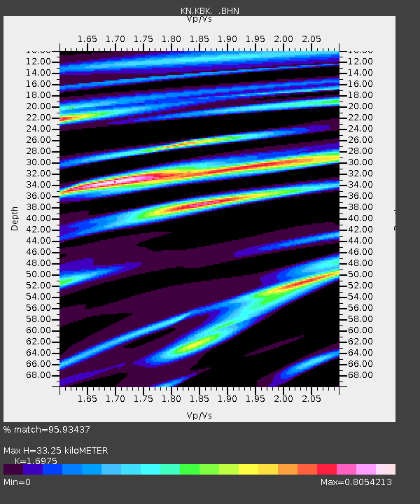
KBK KN.KBK - Earthquake Result Viewer

Earthquake location: Samar, Philippines
Earthquake latitude/longitude: 12.4/125.4
Earthquake time(UTC): 1995/04/23 (113) 05:08:03 GMT
Earthquake Depth: 33 km
Earthquake Magnitude: 6.0 MB, 6.6 MS, 6.7 UNKNOWN, 6.7 MW
Earthquake Catalog/Contributor: WHDF/NEIC
Network: KN Kyrgyz Seismic Telemetry Network
Station: KBK KN.KBK
Lat/Lon: 42.66 N/74.95 E
Elevation: 1760 m
Distance: 52.9 deg
Az: 314.543 deg
Baz: 109.267 deg
Ray Param: 0.06639072
Estimated Moho Depth: 33.25 km
Estimated Crust Vp/Vs: 1.70
Assumed Crust Vp: 6.306 km/s
Estimated Crust Vs: 3.715 km/s
Estimated Crust Poisson's Ratio: 0.23
Radial Match: 95.93437 %
Radial Bump: 400
Transverse Match: 90.878494 %
Transverse Bump: 400
SOD ConfigId: 6273
Insert Time: 2010-03-08 20:12:44.184 +0000
GWidth: 2.5
Max Bumps: 400
Tol: 0.001

Signal To Noise

ChannelStoNSTALTA
KN:KBK: :BHN:19950423T05:16:45.423999Z1.57112341.2362337E-77.868469E-8
KN:KBK: :BHE:19950423T05:16:45.423999Z2.68652182.4878918E-79.260643E-8
KN:KBK: :BHZ:19950423T05:16:45.423999Z8.3534887.6043983E-79.103261E-8
Arrivals
Ps3.9 SECOND
PpPs13 SECOND
PsPs/PpSs17 SECOND