You are here: Home > Network List > IW - Intermountain West Stations List
> Station FLWY Flagg Ranch, Wyoming, USA > Earthquake Result Viewer
FLWY Flagg Ranch, Wyoming, USA - Earthquake Result Viewer
| Earthquake location: |
Near Islands, Aleutian Islands |
| Earthquake latitude/longitude: |
54.0/170.9 |
| Earthquake time(UTC): |
2017/06/02 (153) 22:24:47 GMT |
| Earthquake Depth: |
8.2 km |
| Earthquake Magnitude: |
6.8 Mww |
| Earthquake Catalog/Contributor: |
NEIC PDE/us |
|
| Network: |
IW Intermountain West |
| Station: |
FLWY Flagg Ranch, Wyoming, USA |
| Lat/Lon: |
44.08 N/110.70 W |
| Elevation: |
2078 m |
|
| Distance: |
49.8 deg |
| Az: |
67.534 deg |
| Baz: |
310.843 deg |
| Ray Param: |
0.06846886 |
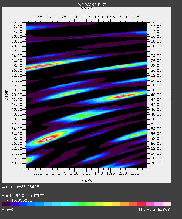
| Estimated Moho Depth: |
58.0 km |
| Estimated Crust Vp/Vs: |
1.69 |
| Assumed Crust Vp: |
6.35 km/s |
| Estimated Crust Vs: |
3.769 km/s |
| Estimated Crust Poisson's Ratio: |
0.23 |
|
| Radial Match: |
88.48628 % |
| Radial Bump: |
400 |
| Transverse Match: |
82.89857 % |
| Transverse Bump: |
400 |
| SOD ConfigId: |
2140511 |
| Insert Time: |
2017-06-16 14:24:08.267 +0000 |
| GWidth: |
2.5 |
| Max Bumps: |
400 |
| Tol: |
0.001 |
|

Signal To Noise
| Channel | StoN | STA | LTA |
| IW:FLWY:00:BHZ:20170602T22:33:10.134996Z | 25.786486 | 2.206154E-6 | 8.555467E-8 |
| IW:FLWY:00:BH1:20170602T22:33:10.134996Z | 7.569694 | 7.385969E-7 | 9.757289E-8 |
| IW:FLWY:00:BH2:20170602T22:33:10.134996Z | 13.008497 | 8.6456856E-7 | 6.646184E-8 |
| Arrivals |
| Ps | 6.6 SECOND |
| PpPs | 23 SECOND |
| PsPs/PpSs | 30 SECOND |


