KBK KN.KBK - Earthquake Result Viewer
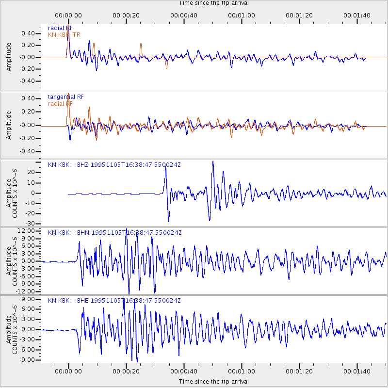
Earthquake location: Southern Sumatra, Indonesia
Earthquake latitude/longitude: -4.9/103.2
Earthquake time(UTC): 1995/11/05 (309) 16:30:00 GMT
Earthquake Depth: 58 km
Earthquake Magnitude: 6.3 MB, 6.1 MS, 5.9 UNKNOWN, 6.3 MW
Earthquake Catalog/Contributor: WHDF/NEIC
Network: KN Kyrgyz Seismic Telemetry Network
Station: KBK KN.KBK
Lat/Lon: 42.66 N/74.95 E
Elevation: 1760 m
Distance: 53.9 deg
Az: 334.358 deg
Baz: 144.235 deg
Ray Param: 0.065655515
Estimated Moho Depth: 17.25 km
Estimated Crust Vp/Vs: 1.85
Assumed Crust Vp: 6.306 km/s
Estimated Crust Vs: 3.418 km/s
Estimated Crust Poisson's Ratio: 0.29
Radial Match: 94.96415 %
Radial Bump: 400
Transverse Match: 94.82008 %
Transverse Bump: 400
SOD ConfigId: 6273
Insert Time: 2010-03-08 20:13:16.634 +0000
GWidth: 2.5
Max Bumps: 400
Tol: 0.001

Signal To Noise

ChannelStoNSTALTA
KN:KBK: :BHN:19951105T16:38:47.550024Z31.5210762.8762083E-69.124715E-8
KN:KBK: :BHE:19951105T16:38:47.550024Z21.8603152.2538359E-61.03101705E-7
KN:KBK: :BHZ:19951105T16:38:47.550024Z174.676479.924138E-65.68144E-8
Arrivals
Ps2.4 SECOND
PpPs7.4 SECOND
PsPs/PpSs9.8 SECOND