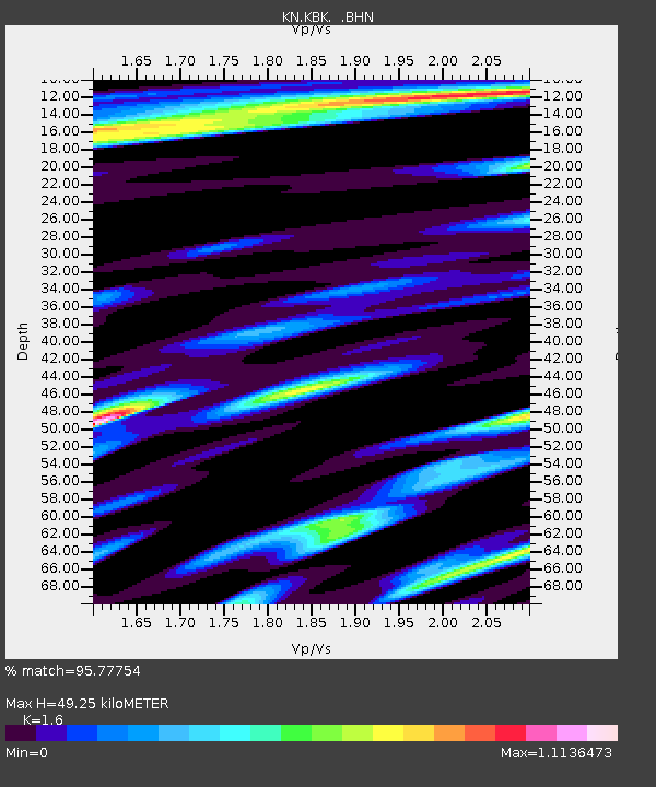
KBK KN.KBK - Earthquake Result Viewer
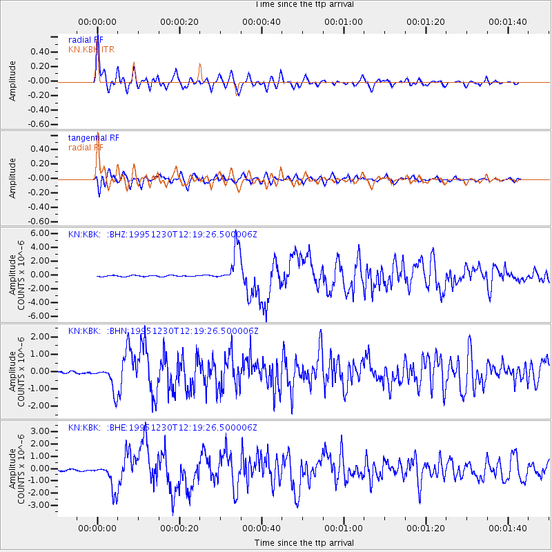
Earthquake location: Off East Coast Of Honshu, Japan
Earthquake latitude/longitude: 40.8/143.4
Earthquake time(UTC): 1995/12/30 (364) 12:11:07 GMT
Earthquake Depth: 33 km
Earthquake Magnitude: 5.7 MB, 6.2 MS, 6.4 UNKNOWN, 6.3 MW
Earthquake Catalog/Contributor: WHDF/NEIC
Network: KN Kyrgyz Seismic Telemetry Network
Station: KBK KN.KBK
Lat/Lon: 42.66 N/74.95 E
Elevation: 1760 m
Distance: 49.8 deg
Az: 296.104 deg
Baz: 67.558 deg
Ray Param: 0.06839773
Estimated Moho Depth: 49.25 km
Estimated Crust Vp/Vs: 1.60
Assumed Crust Vp: 6.306 km/s
Estimated Crust Vs: 3.941 km/s
Estimated Crust Poisson's Ratio: 0.18
Radial Match: 95.77754 %
Radial Bump: 400
Transverse Match: 88.59358 %
Transverse Bump: 400
SOD ConfigId: 6273
Insert Time: 2010-03-08 20:13:28.457 +0000
GWidth: 2.5
Max Bumps: 400
Tol: 0.001

Signal To Noise

ChannelStoNSTALTA
KN:KBK: :BHN:19951230T12:19:26.500006Z6.80230577.179029E-71.0553817E-7
KN:KBK: :BHE:19951230T12:19:26.500006Z17.498491.1709134E-66.6915106E-8
KN:KBK: :BHZ:19951230T12:19:26.500006Z31.7512662.6597115E-68.37671E-8
Arrivals
Ps5.0 SECOND
PpPs19 SECOND
PsPs/PpSs24 SECOND