You are here: Home > Network List > NM - Cooperative New Madrid Seismic Network Stations List
> Station HBAR Harrisburg,AR(CERI) > Earthquake Result Viewer
HBAR Harrisburg,AR(CERI) - Earthquake Result Viewer
| Earthquake location: |
Near Islands, Aleutian Islands |
| Earthquake latitude/longitude: |
54.0/170.9 |
| Earthquake time(UTC): |
2017/06/02 (153) 22:24:47 GMT |
| Earthquake Depth: |
8.2 km |
| Earthquake Magnitude: |
6.8 Mww |
| Earthquake Catalog/Contributor: |
NEIC PDE/us |
|
| Network: |
NM Cooperative New Madrid Seismic Network |
| Station: |
HBAR Harrisburg,AR(CERI) |
| Lat/Lon: |
35.56 N/90.66 W |
| Elevation: |
74 m |
|
| Distance: |
66.6 deg |
| Az: |
61.492 deg |
| Baz: |
320.521 deg |
| Ray Param: |
0.057501487 |
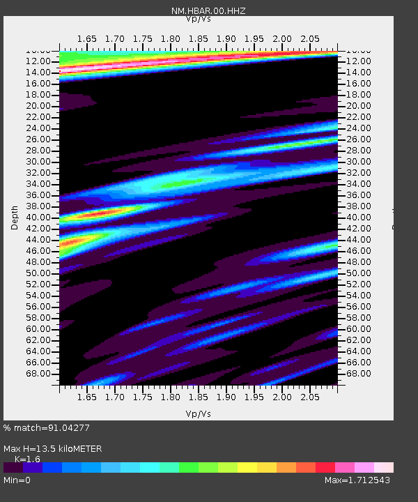
| Estimated Moho Depth: |
13.5 km |
| Estimated Crust Vp/Vs: |
1.60 |
| Assumed Crust Vp: |
6.273 km/s |
| Estimated Crust Vs: |
3.921 km/s |
| Estimated Crust Poisson's Ratio: |
0.18 |
|
| Radial Match: |
91.04277 % |
| Radial Bump: |
400 |
| Transverse Match: |
84.226814 % |
| Transverse Bump: |
400 |
| SOD ConfigId: |
2140511 |
| Insert Time: |
2017-06-16 14:25:42.050 +0000 |
| GWidth: |
2.5 |
| Max Bumps: |
400 |
| Tol: |
0.001 |
|

Signal To Noise
| Channel | StoN | STA | LTA |
| NM:HBAR:00:HHZ:20170602T22:35:07.505022Z | 6.4322762 | 1.8815529E-6 | 2.9251743E-7 |
| NM:HBAR:00:HHN:20170602T22:35:07.505022Z | 1.6287283 | 6.53639E-7 | 4.0131866E-7 |
| NM:HBAR:00:HHE:20170602T22:35:07.505022Z | 2.1752307 | 7.527592E-7 | 3.4605947E-7 |
| Arrivals |
| Ps | 1.3 SECOND |
| PpPs | 5.4 SECOND |
| PsPs/PpSs | 6.7 SECOND |


