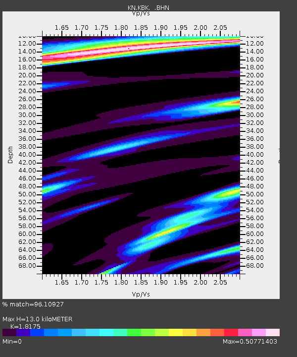
KBK KN.KBK - Earthquake Result Viewer
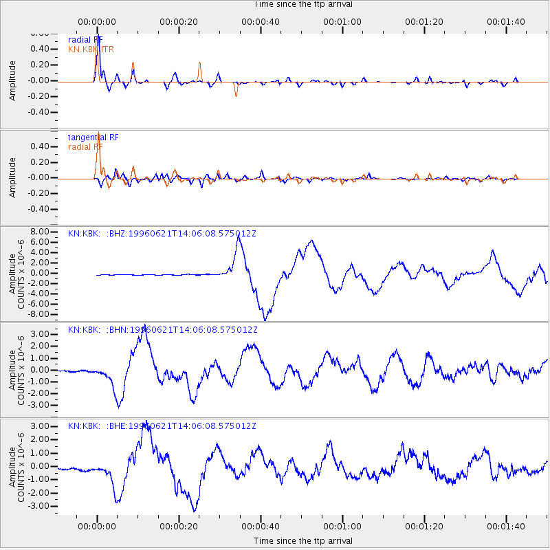
Earthquake location: Off East Coast Of Kamchatka
Earthquake latitude/longitude: 51.6/159.1
Earthquake time(UTC): 1996/06/21 (173) 13:57:10 GMT
Earthquake Depth: 20 km
Earthquake Magnitude: 6.0 MB, 6.6 MS, 7.0 UNKNOWN, 6.5 MS
Earthquake Catalog/Contributor: WHDF/NEIC
Network: KN Kyrgyz Seismic Telemetry Network
Station: KBK KN.KBK
Lat/Lon: 42.66 N/74.95 E
Elevation: 1760 m
Distance: 55.0 deg
Az: 296.309 deg
Baz: 49.327 deg
Ray Param: 0.065090835
Estimated Moho Depth: 13.0 km
Estimated Crust Vp/Vs: 1.82
Assumed Crust Vp: 6.306 km/s
Estimated Crust Vs: 3.47 km/s
Estimated Crust Poisson's Ratio: 0.28
Radial Match: 96.10927 %
Radial Bump: 365
Transverse Match: 92.24081 %
Transverse Bump: 400
SOD ConfigId: 6273
Insert Time: 2010-03-08 20:14:40.799 +0000
GWidth: 2.5
Max Bumps: 400
Tol: 0.001

Signal To Noise

ChannelStoNSTALTA
KN:KBK: :BHN:19960621T14:06:08.575012Z6.60519361.056391E-61.599334E-7
KN:KBK: :BHE:19960621T14:06:08.575012Z2.77563381.1168466E-64.0237535E-7
KN:KBK: :BHZ:19960621T14:06:08.575012Z57.4707572.958778E-65.148319E-8
Arrivals
Ps1.8 SECOND
PpPs5.5 SECOND
PsPs/PpSs7.3 SECOND