You are here: Home > Network List > NM - Cooperative New Madrid Seismic Network Stations List
> Station HENM Henderson Mound,MO > Earthquake Result Viewer
HENM Henderson Mound,MO - Earthquake Result Viewer
| Earthquake location: |
Near Islands, Aleutian Islands |
| Earthquake latitude/longitude: |
54.0/170.9 |
| Earthquake time(UTC): |
2017/06/02 (153) 22:24:47 GMT |
| Earthquake Depth: |
8.2 km |
| Earthquake Magnitude: |
6.8 Mww |
| Earthquake Catalog/Contributor: |
NEIC PDE/us |
|
| Network: |
NM Cooperative New Madrid Seismic Network |
| Station: |
HENM Henderson Mound,MO |
| Lat/Lon: |
36.72 N/89.47 W |
| Elevation: |
88 m |
|
| Distance: |
66.3 deg |
| Az: |
59.881 deg |
| Baz: |
320.574 deg |
| Ray Param: |
0.057689402 |
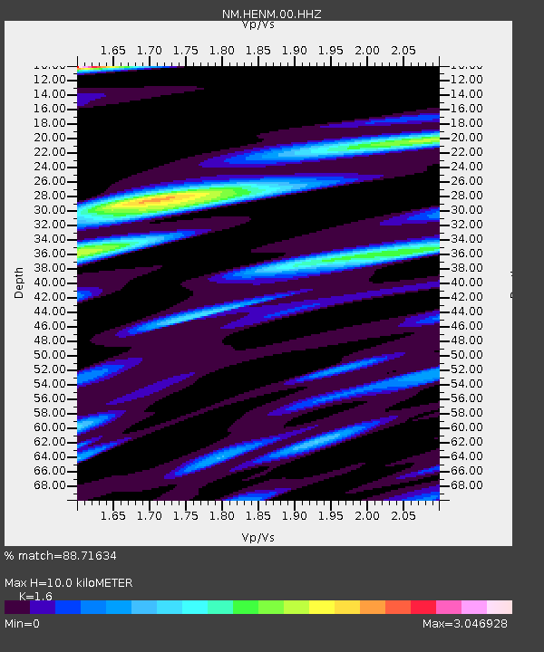
| Estimated Moho Depth: |
10.0 km |
| Estimated Crust Vp/Vs: |
1.60 |
| Assumed Crust Vp: |
6.444 km/s |
| Estimated Crust Vs: |
4.027 km/s |
| Estimated Crust Poisson's Ratio: |
0.18 |
|
| Radial Match: |
88.71634 % |
| Radial Bump: |
400 |
| Transverse Match: |
81.003624 % |
| Transverse Bump: |
400 |
| SOD ConfigId: |
2140511 |
| Insert Time: |
2017-06-16 14:25:45.221 +0000 |
| GWidth: |
2.5 |
| Max Bumps: |
400 |
| Tol: |
0.001 |
|

Signal To Noise
| Channel | StoN | STA | LTA |
| NM:HENM:00:HHZ:20170602T22:35:05.685015Z | 14.761062 | 3.0123022E-6 | 2.0407083E-7 |
| NM:HENM:00:HHN:20170602T22:35:05.685015Z | 3.6823606 | 1.2078743E-6 | 3.280163E-7 |
| NM:HENM:00:HHE:20170602T22:35:05.685015Z | 3.2328384 | 1.0472082E-6 | 3.2392842E-7 |
| Arrivals |
| Ps | 1.0 SECOND |
| PpPs | 3.9 SECOND |
| PsPs/PpSs | 4.8 SECOND |


