You are here: Home > Network List > IW - Intermountain West Stations List
> Station PLID Pearl Lake, Idaho, USA > Earthquake Result Viewer
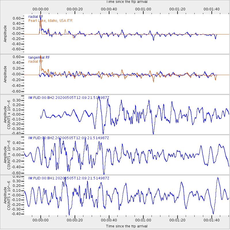
PLID Pearl Lake, Idaho, USA - Earthquake Result Viewer
*The percent match for this event was below the threshold and hence no stack was calculated.
| Earthquake location: |
Near Coast Of Guatemala |
| Earthquake latitude/longitude: |
13.3/-91.1 |
| Earthquake time(UTC): |
2020/05/05 (126) 12:02:32 GMT |
| Earthquake Depth: |
8.0 km |
| Earthquake Magnitude: |
5.5 Mww |
| Earthquake Catalog/Contributor: |
NEIC PDE/us |
|
| Network: |
IW Intermountain West |
| Station: |
PLID Pearl Lake, Idaho, USA |
| Lat/Lon: |
45.09 N/116.00 W |
| Elevation: |
2164 m |
|
| Distance: |
38.1 deg |
| Az: |
331.126 deg |
| Baz: |
138.42 deg |
| Ray Param: |
$rayparam |
*The percent match for this event was below the threshold and hence was not used in the summary stack. |
|
| Radial Match: |
73.223114 % |
| Radial Bump: |
400 |
| Transverse Match: |
46.391594 % |
| Transverse Bump: |
400 |
| SOD ConfigId: |
21166931 |
| Insert Time: |
2020-06-02 12:23:09.692 +0000 |
| GWidth: |
2.5 |
| Max Bumps: |
400 |
| Tol: |
0.001 |
|
Signal To Noise
| Channel | StoN | STA | LTA |
| IW:PLID:00:BHZ:20200505T12:09:21.514987Z | 3.7511077 | 2.9831276E-7 | 7.952658E-8 |
| IW:PLID:00:BH1:20200505T12:09:21.514987Z | 1.5323147 | 1.2057231E-7 | 7.868639E-8 |
| IW:PLID:00:BH2:20200505T12:09:21.514987Z | 3.9481428 | 2.1835271E-7 | 5.5305172E-8 |
| Arrivals |
| Ps | |
| PpPs | |
| PsPs/PpSs | |


