You are here: Home > Network List > NM - Cooperative New Madrid Seismic Network Stations List
> Station LNXT Lenox,TN > Earthquake Result Viewer
LNXT Lenox,TN - Earthquake Result Viewer
| Earthquake location: |
Near Islands, Aleutian Islands |
| Earthquake latitude/longitude: |
54.0/170.9 |
| Earthquake time(UTC): |
2017/06/02 (153) 22:24:47 GMT |
| Earthquake Depth: |
8.2 km |
| Earthquake Magnitude: |
6.8 Mww |
| Earthquake Catalog/Contributor: |
NEIC PDE/us |
|
| Network: |
NM Cooperative New Madrid Seismic Network |
| Station: |
LNXT Lenox,TN |
| Lat/Lon: |
36.10 N/89.49 W |
| Elevation: |
144 m |
|
| Distance: |
66.8 deg |
| Az: |
60.318 deg |
| Baz: |
320.736 deg |
| Ray Param: |
0.057381567 |
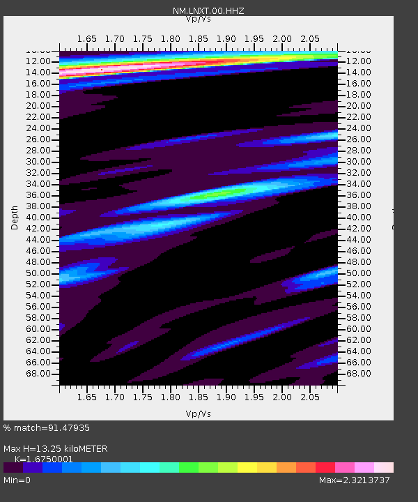
| Estimated Moho Depth: |
13.25 km |
| Estimated Crust Vp/Vs: |
1.68 |
| Assumed Crust Vp: |
6.444 km/s |
| Estimated Crust Vs: |
3.847 km/s |
| Estimated Crust Poisson's Ratio: |
0.22 |
|
| Radial Match: |
91.47935 % |
| Radial Bump: |
400 |
| Transverse Match: |
87.76621 % |
| Transverse Bump: |
400 |
| SOD ConfigId: |
2140511 |
| Insert Time: |
2017-06-16 14:25:55.174 +0000 |
| GWidth: |
2.5 |
| Max Bumps: |
400 |
| Tol: |
0.001 |
|

Signal To Noise
| Channel | StoN | STA | LTA |
| NM:LNXT:00:HHZ:20170602T22:35:08.644976Z | 19.538986 | 3.7190666E-6 | 1.9034081E-7 |
| NM:LNXT:00:HHN:20170602T22:35:08.644976Z | 3.1191692 | 9.541238E-7 | 3.0589035E-7 |
| NM:LNXT:00:HHE:20170602T22:35:08.644976Z | 2.988057 | 1.1188399E-6 | 3.7443732E-7 |
| Arrivals |
| Ps | 1.4 SECOND |
| PpPs | 5.3 SECOND |
| PsPs/PpSs | 6.7 SECOND |


