You are here: Home > Network List > TA - USArray Transportable Network (new EarthScope stations) Stations List
> Station F20K Avaraart Lake, AK, USA > Earthquake Result Viewer
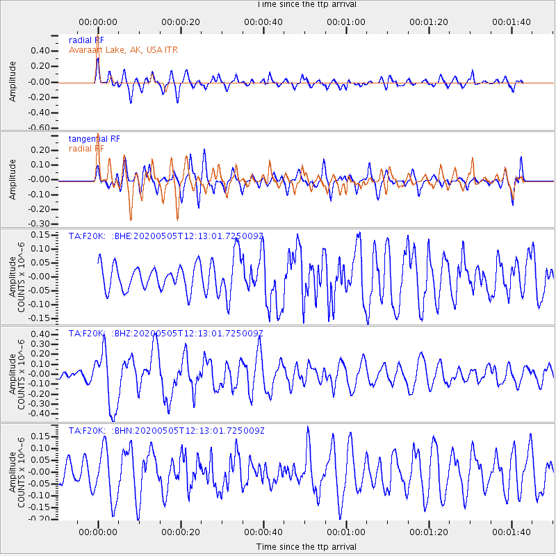
F20K Avaraart Lake, AK, USA - Earthquake Result Viewer
*The percent match for this event was below the threshold and hence no stack was calculated.
| Earthquake location: |
Near Coast Of Guatemala |
| Earthquake latitude/longitude: |
13.3/-91.1 |
| Earthquake time(UTC): |
2020/05/05 (126) 12:02:32 GMT |
| Earthquake Depth: |
8.0 km |
| Earthquake Magnitude: |
5.5 Mww |
| Earthquake Catalog/Contributor: |
NEIC PDE/us |
|
| Network: |
TA USArray Transportable Network (new EarthScope stations) |
| Station: |
F20K Avaraart Lake, AK, USA |
| Lat/Lon: |
67.05 N/155.73 W |
| Elevation: |
136 m |
|
| Distance: |
68.1 deg |
| Az: |
337.545 deg |
| Baz: |
108.516 deg |
| Ray Param: |
$rayparam |
*The percent match for this event was below the threshold and hence was not used in the summary stack. |
|
| Radial Match: |
75.89053 % |
| Radial Bump: |
400 |
| Transverse Match: |
64.369995 % |
| Transverse Bump: |
400 |
| SOD ConfigId: |
21166931 |
| Insert Time: |
2020-06-02 12:27:34.357 +0000 |
| GWidth: |
2.5 |
| Max Bumps: |
400 |
| Tol: |
0.001 |
|
Signal To Noise
| Channel | StoN | STA | LTA |
| TA:F20K: :BHZ:20200505T12:13:01.725009Z | 7.871851 | 2.9879578E-7 | 3.7957502E-8 |
| TA:F20K: :BHN:20200505T12:13:01.725009Z | 1.9108374 | 1.1111863E-7 | 5.8151798E-8 |
| TA:F20K: :BHE:20200505T12:13:01.725009Z | 2.056809 | 8.6638E-8 | 4.2122533E-8 |
| Arrivals |
| Ps | |
| PpPs | |
| PsPs/PpSs | |


