You are here: Home > Network List > TA - USArray Transportable Network (new EarthScope stations) Stations List
> Station G22K Bettles, AK, USA > Earthquake Result Viewer
G22K Bettles, AK, USA - Earthquake Result Viewer
| Earthquake location: |
Near Coast Of Guatemala |
| Earthquake latitude/longitude: |
13.3/-91.1 |
| Earthquake time(UTC): |
2020/05/05 (126) 12:02:32 GMT |
| Earthquake Depth: |
8.0 km |
| Earthquake Magnitude: |
5.5 Mww |
| Earthquake Catalog/Contributor: |
NEIC PDE/us |
|
| Network: |
TA USArray Transportable Network (new EarthScope stations) |
| Station: |
G22K Bettles, AK, USA |
| Lat/Lon: |
66.92 N/151.51 W |
| Elevation: |
205 m |
|
| Distance: |
66.5 deg |
| Az: |
338.047 deg |
| Baz: |
112.588 deg |
| Ray Param: |
0.057607178 |
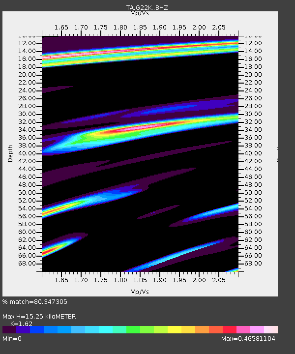
| Estimated Moho Depth: |
15.25 km |
| Estimated Crust Vp/Vs: |
1.62 |
| Assumed Crust Vp: |
6.577 km/s |
| Estimated Crust Vs: |
4.06 km/s |
| Estimated Crust Poisson's Ratio: |
0.19 |
|
| Radial Match: |
80.347305 % |
| Radial Bump: |
400 |
| Transverse Match: |
65.385345 % |
| Transverse Bump: |
400 |
| SOD ConfigId: |
21166931 |
| Insert Time: |
2020-06-02 12:27:54.752 +0000 |
| GWidth: |
2.5 |
| Max Bumps: |
400 |
| Tol: |
0.001 |
|

Signal To Noise
| Channel | StoN | STA | LTA |
| TA:G22K: :BHZ:20200505T12:12:51.624972Z | 5.9993153 | 3.8296182E-7 | 6.383425E-8 |
| TA:G22K: :BHN:20200505T12:12:51.624972Z | 1.0868721 | 9.629615E-8 | 8.8599336E-8 |
| TA:G22K: :BHE:20200505T12:12:51.624972Z | 2.460612 | 1.5481223E-7 | 6.291614E-8 |
| Arrivals |
| Ps | 1.5 SECOND |
| PpPs | 5.8 SECOND |
| PsPs/PpSs | 7.3 SECOND |


